
Last Updated on 15/12/2025 by Louise
The mountainous region of Bannau Brycheiniog (The Brecon Beacons) in South Wales has a long history as a military training ground. The beautiful landscape of the Beacons can prove treacherous in harsh conditions and the SAS still use this challenging terrain for training exercises.
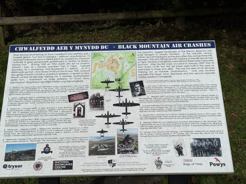
The Brecon Beacons is home to 40 aircraft crash sites, although there are only a few sites with reamins of notable wreckage. One of these sites is the Wellington Bomber crash site at Carreg Goch, near Glyntawe.
Access to this site is a via a short but picturesque hike across the western Beacons, known as the Black Mountain region or the Carmarthern Fans. The walk has a fairly steep climb initially but the 360 degree views from the summit are certainly worth the effort. The area feels rugged and remote with piles of rocky outcrops and sinkholes littering the landscape.
In this guide to walking the Carreg Goch Wellington Bomber crash site I provide a detailed hike description, distances, times and photos.

Disclaimer: Some links in this article are affiliate links, which means that if you purchase through them I receive a small commission, at no extra cost to you. This helps cover the cost of running this blog. Thanks for your support!
About the Carreg Goch Crash Site
The tragic story of the Vickers Wellington Bomber MF509 began on the night of November 20th 1944 from Operational Training Unit, Wellesbourne, Mountford. The aircraft set out on a nighttime cross-country training exercise but developed trouble with their engine.
The engine problem forced them into clouds which resulted in heavy ice forming on the wings. The impaired engine wasn’t able to generate enough power to maintain height and the aircraft crashed into the southwest slopes of Carreg Goch. All six Canadian crew were killed.
A memorial cairn now stands in their memory with the names of crew inscribed on on a plaque. The six men killed were:
- Sgt. Charles Hamel – Pilot
- Sgt: Jules Robert Rene Villeneuve – Navigator
- F/Off. William Joseph Allison -Bomb Aimer
- Sgt. Joseph Paul Ernest Burke – Air Gunner
- Sgt. Arthur Grouix – Air Gunner
- Sgt.Gerard Dusablon – Air Gunner


Carreg Goch Wellington Bomber Walking Route Description
- Starting location: Dan Yr Ogof Campsite
- Distance: 8km
- Time: 3-4hrs
- Elevation gain: 340m
- Difficulty: Moderate
- Map: OS Explorer OL12 Brecon Beacons National Park
- How to Pronounce: Kar-reg Gor-ch soft ch as in loch
- Meaning: Red stone
For this hike there are several parking options but the easiest and most convenient is the Dan Yr Ogof Campsite. To get here drive into the main entrance to Dan Yr Ogof and then turn right to head towards the campsite. Here you will find ample parking along the left and right of the road.
From the car park, walk towards the campsite until you reach an information board that displays the details and locations of aircraft crashes in the Black Mountain. You will then see a footpath sign that says “To Mountain Footpath”. Follow that footpath!
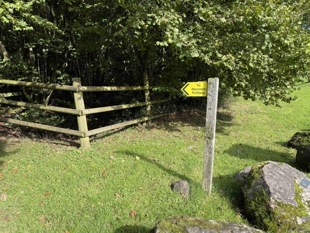
This shaded footpath makes a gradual climb towards to the mountainside. Once you pass through a gate you will see a blue bridleway signpost pointing to the left. Follow this signpost to get onto the mountain proper and follow the footpath around to the left.
As you begin to ascend you can appreciate views of the Tawe valley and Fan Gyhirych peak behind you.

Around 400m later, the trail again branches into two. Continue straight ahead for a more gradual ascent or turn right for a short-cut that leads directly up the hill. Walk along this well trodden path for around 1.3km. Here you will leave the main path and begin walking along smaller sheep/pony tracks. This is where navigation becomes tricky, especially in poor weather and use of a GPS or map and compass is required.
Follow the pony tracks in a westerly direction as they make their way towards the hill summit. After 10-15 minutes, upon reaching the first plateau the tracks fork. The trail to the right heads directly to the summit, but instead branch off to the left along the plateau and make your way to the small lake.

Take a moment to enjoy the flora and fauna around the lake before taking a track off to the right (not marked on maps.me). This track climbs up the hill and leads to the rocky summit of Carreg Goch (558m). From here there are fabulous 360 degree views from atop this intriguing limestone rock layer.
This is a good place to enjoy lunch and admire the views. At this point, the crash site is only 200m below in a westerly direction, however it remains hidden out of site .


There are two options from the summit. You can head south and descend the ridge along the rock tables to rejoin the marked path. Upon reaching the path turn right and follow the trail as it turns back in a northerly direction. A few minutes after turning north you will see the crash site straight ahead of you.
Alternatively, from the summit, cut across country in a westerly direction making your way straight down the hill. The ground consists or rock slabs and tufty grass but is fairly easy to walk across. Just 5 – 10 minutes after leaving the summit you will see the crash site below.
At the crash site you will find recognisable remains of the bombers wings, landing gear and main body. There is a memorial cairn with two plaques, the most recent of which was laid in 2006 to commemorate the visit of one of the crew’s surviving sisters.
From the crash site, the path continues in a northerly direction in the direction of the Camarthern Fans (Fan Brycheiniog, Fan Foel, Picws Du). There are a few more sections of wreckage to investigate away from the main site, off to the right of the path. Shortly after leaving the site, the path becomes more established and remains this way for the rest of the walk.
Follow the path northwards before it comes to a t-junction. Turn right and make your way eastwards towards the start of the hike. The path gradually descends through the valley with Fan Hir ridge and a fenced boggy area off to the left. Fan Hir ridge is the location for another aircraft crash site, Vampire jet VZ106, which crashed in 1953. Click here for a guide to visiting this wreckage.
Fan Hir ridge is also the start of an epic hike to the beautiful Llyn y Fan Fach and Llyn y Fan Fawr. See this guide to learn more.
Soon you will reach the point where you left the main path on the ascent. From here you can simply retrace your steps back to the starting point. Be sure to watch out for the left turn above Cwm Haffes, above the river crossing, where the right turn leads to Dan Yr Ogof Farm.
What is the grid reference for Carreg Goch Wellington Bomber Crash Site?
The crash site can be found at Grid Reference: SN817168
Related Reading
- Blaen-y-Glyn Wellington Bomber walking loop
- The 12 best hikes in the Brecon Beacons
- Top things to do in the Brecon Beacons
Hiking the Canadian Bomber Crash Site – What do you need?
- Suitable clothing: warm layers and waterproofs
- Water, food, snacks: filtering water bottles are very handy for safely refilling in streams and rivers. You can read more about filtering water bottles in this guide. Psst! I’ve secured a deal for all readers of this website. Simply use the code WWG15 at checkout to get a 15% discount off all Water-to-go bottles and filters.
- Quality hiking boots or trail shoes are a must
- The relevant map and compass, and the ability to use them!
- A first aid kit for hiking
- GPS or mapping app:A great free app option is maps.me, although the free features have now become limited. I have an annual subscription to OS which means I have access to all UK OS maps on my mobile. I can definitely recommend it if you’re a regular hiker/walker.
These are just some of the essentials, but for a complete list of things to take on a hike in Wales, take a look at this guide!
Prefer not to walk alone? If you’re looking for a Mountain Leader to guide you on a mountain adventure, please contact me at wanderingwelshgirl1@gmail.com to discuss rates and availability.
Final Thoughts on Walking to the Crash Site
Wellington Bomber MF509 tragically crashed into the side of Carreg Goch peak in November 1944 and much of the aircraft wreckage remains to this day. All six Canadian crew were killed in the crash and a cairn at the site marks their memory. The easiest way to access the crash site is a via hike from Glyntawe.
In this guide I provide a detailed description of this Wellington Bomber crash site walk. The loop is 8km in length, takes around 3-4 hours and is classed as moderate due to the initial climb up to Carreg Goch summit.
Join My Newsletter Today
Recent Posts
11 Best Waterfalls in South Wales (With Videos & Parking Locations): 2026 Edition
South Wales is a waterfall lover’s paradise. With ancient woodland, dramatic gorges, and mountain-fed rivers, this region boasts some of the UK’s most spectacular waterfalls. Tucked away in the...
Athens' modern-day charm might captivate many tourists, but its historic side, represented by the glorious Acropolis, is unmatched. This beautiful landmark is a powerful reminder of ancient history...