
Last Updated on 09/06/2026 by Louise
Wales, a land of myth and legend, is a hiker’s paradise with its dramatic landscapes, lush valleys, and rugged coastlines. From the towering peaks of Eryri to the serene shores of Pembrokeshire, Wales offers an array of breathtaking day hikes that cater to all levels of adventurers.
Each trail provides a unique glimpse into the country’s natural beauty and cultural heritage, making it an ideal destination for outdoor enthusiasts. Growing up on the edge of Bannau Brychieniog (Brecon Beacons) and working as a Mountain Leader in Eryri (Snowdonia), I’ve spent a lot of time exploring the small country I call home. As a result, I decided to put together this helpful guide.
The three National Parks of Eryri, Bannau Brychieniog and Pembrokeshire Coast naturally feature heavily in this list but there are also some hikes outside of these areas that are equally impressive. In this guide, we will journey through the best day hikes in Wales, highlighting the must-visit routes that promise not only physical challenge and adventure but also unforgettable vistas and moments of tranquility.

Disclaimer: Some links in this article are affiliate links, which means that if you purchase through them I receive a small commission, at no extra cost to you. Thank you! This helps cover the cost of running this blog and keep all resources free to access 🙂
The Best Hikes In Wales
1. Yr Wyddfa Horseshoe (Snowdon Horseshoe)
- Distance: 12km
- Elevation gain: 1062m
- Time: 8+ hours
- Difficulty: Strenuous
- Starting Point: Pen y Pass (Take the Sherpa Bus from Llanberis)
- Map: OS Explorer OL17
- Highlights: Crib Goch traverse
The Snowdon Horseshoe refers to the horseshoe shaped ring of peaks that make up part of the Snowdon Massif. This fabulous ridge walk provides incredible views throughout, making it one of the best hikes in Snowdonia (Eryri).
This challenging mountain day takes in several Eryri/Snowdonia ridges and summits and should only be attempted by experienced hikers and those comfortable with scrambling and exposed edges.
This Yr Wyddfa circuit starts from Pen y Pass, following the well signposted PYG Track towards the highest peak in Wales. If you’re interested in discovering easier routes to the summit of Snowdon, take a look at this post.
Upon reaching Bwlch y Moch the route branches away from the PYG track and leads to the first scramble of the day, to the summit of Crib Goch. Once at the top you will begin the traverse of Crib Goch arête, which is 500m of exposed, rocky, ridge scrambling.
With the excitement of Crib Goch over, there’s another ridge scramble onto the second highest point in Wales, Garnedd Ugain. From here it’s a straightforward walk onto Yr Wyddfa summit to join the crowds, before descending via the Watkin Path to Bwlch y Saethau.
The final summit of the day, Y Lliwedd, involves some more, albeit easier, scrambling before beginning the gradual descent towards Llyn Llydaw, where the route joins up with the well trodden Miners Track to complete the loop back to Pen y Pass.


2. Pen y Fan Horseshoe (Beacons Horseshoe)
- Distance: 15.3km
- Elevation gain: 785m
- Time: 5-7 hours
- Difficulty: Challenging
- Starting Point: Neuadd car park
- Map: OS Explorer OL12 Brecon Beacons National Park
- Highlights: Bagging the highest peak in Southern Britain
Pen y Fan is the highest peak in the Bannau Brycheiniog/Brecon Beacons National Park and for this reason it attracts many visitors. The easiest route to the top, and the most popular walk in the Bannau Brycheiniog/Brecon Beacons, is from the A470 road at Pont ar Daf car park.
However, the best Pen y Fan hike and one of the top UK hikes is a full day hike that incorporates several of the surrounding peaks and is known as the Beacons horseshoe ridge walk.
Starting from the quieter Neuadd car park, the horseshoe trek ascends the ridge to the west and circles the Taf Fechan valley. This is a prime example of a steep sided glacial valley in the Bannau Brycheiniog/Brecon Beacons.
En-route, hikers will summit multiple peaks including Corn Du, Pen y Fan, Cribyn and Fan y Big. As you might imagine, with all of these mountains to summit there is a lot of up and down on this hike, so be prepared!


3. The Carmarthen Fans (Bannau Sir Gaer)
- Distance: 22 km
- Elevation gain: 1017m
- Time: 7–8 hours
- Difficulty: Challenging
- Starting Point: Tafarn-y-Garreg pub in Glyntawe
- Map: OS Explorer OL12 Brecon Beacons National Park
- Highlights: Spectacular ridge walking with mountain lake views
This is easily my favourite Bannau Brycheiniog/Brecon Beacons walk, as it has epic ridge walking, glacial lakes and superb mountain views. This walk is in the Black Mountain area which is in the west of the National Park. The mountain range is the location of several aircraft crash sites including the Wellington Bomber on Carreg Goch and the Vampire Jet on Fan Hir.
From the Tawe Valley the hike climbs steeply up a grassy hillside to the first peak, Fan Hir. There is a drop into the saddle before climbing back up to Fan Brycheiniog and then onto Fan Foel at the end of the ridge.
At Fan Foel the route heads west to drop into another saddle, before ascending to the next peak of Picws Du. It then continues around and down to the first lake, Llyn y Fan Fach. The return section skirts along the steep escarpments past a second lake, Llyn y Fan Fawr, and along the valley, past several cascades back to the car park.
This is a truly epic mountain day and one not to be missed! The walk can be shortened to 13.2 km, through doing an out and back hike to Fan Foel.


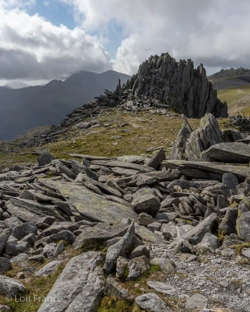
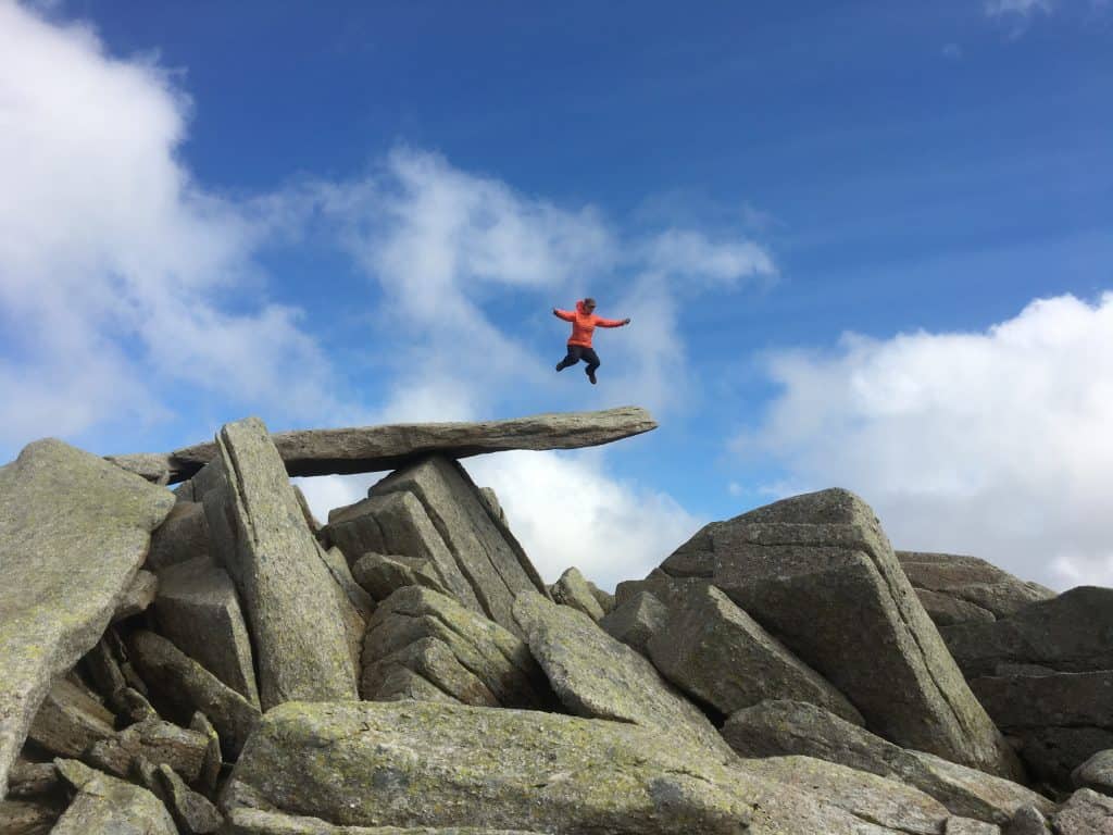
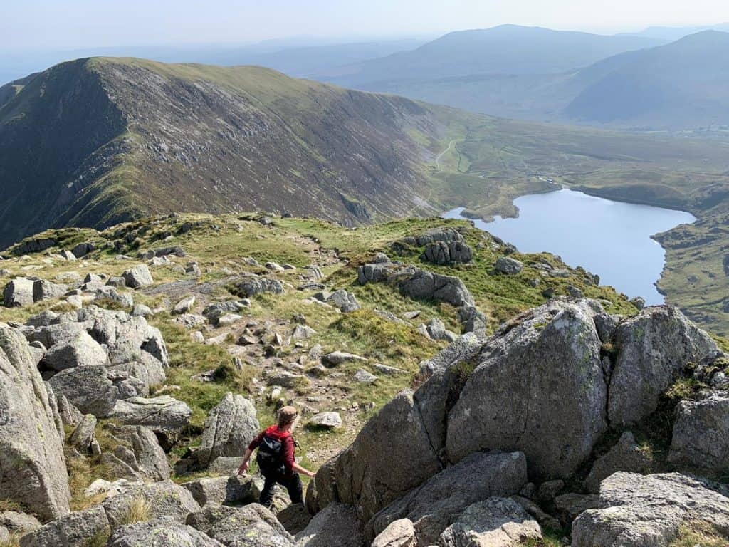
4. The Ultimate Glyderau Loop
- Distance: 14.5km
- Elevation gain: 1143m
- Time: 7-9 hours
- Difficulty: Strenuous
- Starting Point: Lay-bys at the base of Tryfan on the A5, Ogwen Valley
- Map: Os Explorer OL17
- Highlights: North Ridge of Tryfan and the Cantilever Stone
The Glyderau (commonly referred to as the Glyders) is a range of mountains in Eryri (Snowdonia) National Park that are famed for their rugged rock formations. This hike of the Glyderau is an epic day out that includes climbing four peaks – Tryfan, Glyder Fach, Glyder Fawr and Y Garn.
This hike should only be attempted by experienced hikers as it involves the notorious scramble up the north ridge of Tryfan. An easier option to skip the north ridge is the Heather Terrace, however whichever route you take up Tryfan, some scrambling is required.
Confident hikers can go on to tackle another difficult scramble of Bristly Ridge however an easier option involves following the Miners Track to the summit of Glyder Fach. Enjoy classic photos on the Cantilever Stone before continuing on past Castell y Gwynt and on to Glyder Fawr.
The descent off Glyder Fawr down loose scree is unkind on tired knees but it doesn’t last too long. The loop can be shortened here through opting to descend via the Devil’s Kitchen to Cwm Idwal. However, to complete this four peak wonder, make the ascent to Y Garn where you can enjoy fabulous views over the Ogwen Valley.
Complete the loop through descending Y Garn via the north ridge to Cwm Idwal, before walking back along the A5 to the starting point.

5. The Four Falls Loop
- Distance: 8.8km round trip
- Elevation gain: 235m
- Time: 3-4 hours
- Difficulty: Moderate
- Starting Point: Cwm Porth car park
- Map: OS Explorer OL12 Brecon Beacons National Park
- Highlights: Walking behind a raging waterfall
The four falls trail sits right in the heart of Waterfall Country and is one of the most popular waterfall walks in the Bannau Brycheiniog/Brecon Beacons. From the car park in Cwm Porth there is a well marked trail that will guide walkers towards Sgwd-yr-Eira on the river Heptse. The car park requires a payment but does have toilet facilities.
Along the route there are side trails that lead to several other waterfalls along the River Mellte. These waterfalls are Sgwd Clun-Gwyn, Sgwd Isaf Clun-Gwyn and Sgwd y Pannwr.
This marked trail is suitable for families. The trail itself is mostly flat but the sections leading down to the waterfalls themselves are steep and often muddy. With children I would recommend heading straight for Sgwd-yr-Eira, and then visit the other waterfalls on the return journey if they still have the energy!
Whilst all the waterfalls on this trail are beautiful, the climax of the walk is Sgwd-yr-Eira or fall of snow, as it translates. The big attraction of this falls is the ability to easily walk along the rocks behind the raging waterfall.
Be warned the rocks are wet and slippery and you are likely to get wet from the spray! Do not attempt after heavy rainfall or if the waterfall is in full force.


6. Pen yr Ole Wen and The High Carneddau
- Distance: 15km
- Elevation gain: 980m
- Time: 7 hours
- Difficulty: Challenging
- Starting Point: Glan Denau on the A5
- Map: OS Explorer OL17
- Highlights: Strolling along the ridge between Daffydd and Llywelyn
The Carneddau are big mountains with many of the highest peaks in Eryri (Snowdonia). If you’re looking for a big mountain day with a large amount of up, then this hike is for you!
This route climbs Pen yr Ole Wen from the east which includes a short but straightforward scramble. Then there is a short climb to Carnedd Dafydd followed by a ridge walk and another short climb to Carnedd Llywelyn.
From the highest peak there is some steep loose scree on the descent followed by another, quite technical rock slab scramble, before reaching Ffynnon Llugwy and a chance to dip your feet in the cool waters. A walk down the road, followed by a march along the old Roman Road is then required to get back to the starting point.

7. The Nantlle Ridge
- Distance: 14.5km
- Elevation gain: 1077.5mm
- Time: 5-8 hours
- Difficulty: Moderate
- Starting Point: Rydd Ddu car park
- Map: Os Explorer OL17
- Highlights: Summit 7 peaks along a spectacular ridge walk
The Nantlle Ridge is a range of mountains on the west side of Eryri (Snowdonia) National Park. This stretch of mountains includes severn peaks ranging between 600 meters and 800 meters in height.
The Nantlle Ridge traverse is 14.5km in length and gains over 1000m in height. Although this ridge is nowhere near as technical as the Snowdon Horseshoe nor as long as a traverse of the Carneddau, it offers incredible views throughout and is edgy enough to provide that true ridge feeling.
A traverse of this ridge can be walked in either direction but involves two cars or the use of public transportation. The start and end points are Rhydd Ddu car park and the village of Nebo.


8. Worms Head and Rhosilli Bay
- Distance: 5km (3miles)
- Elevation gain: 90m
- Time: 4 hours
- Difficulty: Moderate (Slippery rocks)
- Starting Point: National Trust car park at Rhossili
- Map: OS Explorer 164
- Highlight: Walking over the Devil’s Bridge
Worms’s Head is a tidal island at the most westerly point of the Gower Peninsula in South Wales. Worm’s Head gets its name from the Norse word wurm, meaning Dragon. From a distance at low tide, the rocky island resembles that of a sleeping dragon.
This is a fun walk in the Gower which was Wales’ first designated Area of Outstanding Natural Beauty. For 2.5 hours either side of low tide it’s possible to walk out to the end of the Worm’s Head and the walk involves some rock hopping to get across the causeway. (Boots highly recommended)
From Rhossili village walk out to the coast guard station, where you can double check the tide times. Descend from the headland onto the causeway and tip-toe your way across the slippery rocks.
Once across the causeway, follow the path to the left and along the top of the inner headland. Cross over a section of jagged rocks and then cross the natural rock bridge, disconcertingly called Devil’s Bridge, before climbing up onto the outer headland. A short but steep scramble is required to access outer headland.


From the 1st March to the 31st August the outer headland maybe closed and inaccessible to walkers, in order to protect nesting seabirds. Enjoy fantastic views back across to Rhossili Bay but keep an eye on the time so you don’t get stranded! Then simply retrace your steps back to Rhossili village to complete the walk.
This walk can be extended to include views of Falls Bay and Mewslade Bay (two beautiful beaches on the Gower) by turning right once you get back onto the headland. Follow the coastal path around past the bays, before cutting back across country to finish in Rhossili.
9. Cader/Cadair Idris Minffordd Path Loop
- Distance: 9.2km
- Elevation gain: 862m
- Time: 5-6 hours
- Difficulty: Moderate
- Starting Point: Minffordd Car Park
- Map: OS Explorer OL23
- Highlights: The ridge walk to Craig Cwm Amarch
Cader Idris or Cadair Idris is found in Southern Eryri/Snowdonia away from main hub surrounding Yr Wyddfa/ Mount Snowdon. This loop provides a beautiful scenic walk and is a must-do for anyone exploring Eryri/Snowdonia National Park.
There are various routes to the summit of Cader Idris, but the Minffordd Path offers a great ridge walk with views of Cwm Cau along the way. This loop starts from the car park at Minffordd and follows a well trodden path through a pretty wooded gorge. Be warned there are lots of steps on this trail but it at least gets lots of the climbing over and done with.
Keeping left at both forks the effort is soon rewarded with views of Llyn Cau and Cadair peak. After admiring the views the ridge climb begins to the first summit of Craig Cwm Amarch. From this peak there is a short descent to the bwlch, before making the final climb to Cadair summit.
Cadair Idris is a popular Eryri/Snowdonia hike so don’t expect to have the summit to yourself however the panoramic views make this a hike not to be missed. Once you’ve taken in the views it’s time to continue the loop along the ridge towards Mynydd Gwerngraig before heading down into the valley to return to the car park.

10. Chepstow to Tintern Abbey
- Distance: 9.3km
- Elevation gain: 481m
- Time: 3-4 hours
- Difficulty: Easy-Moderate
- Starting Point: Chepstow Tourist Information centre (car park)
- Map: OS Explorer OL14
- Highlights: The Eagle’s Nest
The Wye Valley Walk is a long distance walking route running from Llanidloes in mid Wales to Chepstow in the south. The route covers 136 miles through dense woodland, along a dramatic gorge and across tranquil river meadows. It takes around 10 days to complete the walk and is a beautiful multi-day hike in Wales.
One great one day walking option is from Chepstow to Tintern Abbey. Starting from Chepstow, this picturesque trail follows the course of the Wye River as it meanders through ancient woodlands and along cliffside edges. Before the walk, be sure to explore the magnificent Chepstow Castle and enjoy views over the Wye River from the towering battlements.
A highlight of this walk is the Eagle’s Nest viewpoint which offers a fabulous vista of the Wye Valley and Severn Estuary beyond. During springtime walkers here can enjoy colourful carpets of bluebells and wild garlic.
The trail finishes at the incredible Tintern Abbey. One of the most popular historic sites in the Wye Valley, Tintern Abbey was founded in 1131 by Cistercian monks but was abandoned during the dissolution of the monasteries. Today, Tintern Abbey stands as one of the best-preserved monastic ruins in Wales and is a site not to be missed.


11. Bosherton Lily Ponds Loop
- Distance: 7.1km
- Elevation gain: Marginal
- Time: 3 hours
- Difficulty: Easy
- Starting Point: National Trust car park at Bosherton
- Map: Os Explorer OL36
- Highlights: Broad Haven Beach and St Govan’s Chapel
This delightful coastal walk includes wandering past pretty ponds covered in lily pads, a stroll along the top Pembrokeshire sandy beach of Broad Haven, a hike along rugged clifftops and the exploration of a 6th century chapel. This walk is well sign posted and easy to follow, and is one of Pembrokeshire’s best walks in my opinion.
Founded in the 6th century, St Govan’s is a remarkable little chapel built into the side of a limestone cliff on St Govan’s Head. I first discovered St Govan’s purely by accident, whilst enjoying this hike from Bosherton. I definitely recommend the complete Bosherton Lilly Ponds loop, however there is road access to St Govan’s if you don’t want a long walk.
The walk to St Govan’s Head and Chapel passes through a military firing range so call ahead to check the range is open to the public. Access to the chapel is a via a steep set of stairs. Legend has it that if you count the stairs on the way down and then again on the way back up, the number is never the same! Surely it’s well worth a visit just to find out?!


You might also like
- Top hikes from around the world
- The best healthy snacks to take on your next hike
- Unmissable hikes in the UK
- Top apps for hiking in the UK
What to Take on a Day Hike In Wales?
- Suitable clothing: warm layers and waterproofs
- Water, food, snacks: filtering water bottles are very handy for safely refilling in streams and rivers. You can read more about filtering water bottles in this guide. Psst! I’ve secured a deal for all readers of this website. Simply use the code WWG15 at checkout to get a 15% discount off all Water-to-go bottles and filters.
- Quality hiking boots or trail shoes are a must
- The relevant map and compass, and the ability to use them!
- A first aid kit for hiking
- GPS or mapping app:A great free app option is maps.me, although the free features have now become limited. I have an annual subscription to OS which means I have access to all UK OS maps on my mobile. I can definitely recommend it if you’re a regular hiker/walker.
These are just some of the essentials, but for a complete list of things to take on a hike in Wales, take a look at this guide!
How To Get To These Hikes in Wales
Public transport can be used to get to many of these hikes, particularly around Snowdonia. Most of the Snowdonia hikes are serviced by Sherpa’r Wyddfa, however getting to the area itself isn’t always that straightforward.
National bus routes run from major cities around the UK to various parts of Wales, which then connect to local bus networks. Use Busbud to find the best route for you. National rail also has a limited amount of train routes from major cities to starting points of these hikes, the most popular of which are Cardiff in South Wales and Bangor in the North. Check out train routes and availability on Trainline.
The easiest way to get to the starting locations or to get between hikes is by using a car. Discover cars is a search engine which helps you to find the best deals on car rentals in the UK and beyond.
Final Thoughts on these Top Welsh Hikes
Wales holds a treasure trove of hiking opportunities, each offering unique landscapes and experiences. Whether you seek the challenge of a mountain peak or the serenity of a coastal path, these one-day hikes showcase the best of what Wales has to offer. Lace up your boots, pack your essentials, and embark on an unforgettable journey through some of the most beautiful and varied terrains in the UK.
Prefer not to walk alone? If you’re looking for a Mountain Leader to guide you on a mountain adventure, please contact me at wanderingwelshgirl1@gmail.com to discuss rates and availability.
Recent Posts
11 Best Waterfalls in South Wales (With Videos & Parking Locations): 2026 Edition
South Wales is a waterfall lover’s paradise. With ancient woodland, dramatic gorges, and mountain-fed rivers, this region boasts some of the UK’s most spectacular waterfalls. Tucked away in the...
Athens' modern-day charm might captivate many tourists, but its historic side, represented by the glorious Acropolis, is unmatched. This beautiful landmark is a powerful reminder of ancient history...