
Last Updated on 15/11/2024 by Louise
The Blorenge is a mountain in the southeastern corner of the Brecon Beacons (Bannau Brycheiniog) which overlooks the River Usk. From the summit of the Blorenge, walkers can enjoy stunning views of the Black Mountains, Central Beacons and the Severn Estuary.
However, a Blorenge walk can offer much more than just great views. With its abundance of heather moorland, this rounded peak is an important breeding ground for Red Grouse. The area also offers visitors sightings of polecats, weasels, badgers, foxes and adders. And for those interested in history, the Blorenge played an important role in the Industrial Revolution taking place at nearby Blaenavon.
In this guide I describe three walking routes that explore this fascinating hill.
Disclaimer: Some links in this article are affiliate links, which means that if you purchase through them I receive a small commission, at no extra cost to you. Thank you! This helps cover the cost of running this blog and keep all resources free to access 🙂
The Blorenge
Blorenge or the Blorenge, is a peak in the Brecon Beacons National Park. Blorenge hill, which tops out at 561m (1841ft), is also designated a Site of Special Scientific Interest due to its abundance of heather moorland. A section of the lower hill known as the Punchbowl, is a nature reserve managed by the Woodland trust.
From the summit of the Blorenge, the flat topped peak of Sugar Loaf will instantly stand out as the biggest and closest hill, standing proud to the north of Abergavenny. To the east of Abergavenny walkers will recognise the stand alone mountain of Skirrid. Finally if you are blessed with clear weather, to the east you can pick out the largest peak in the Beacons, Pen y Fan.
The Blorenge is located between Llanfoist and Blaenavon, which is a World Heritage Site. Given this location, the Blorenge is steeped in Industrial Heritage.
Blaenavon was a leading producer of iron and limestone which was distributed all over the world. A tramroad was built to connect Blaenavon to Llanfoist Wharf, which then connected to the Monmouthshire and Brecon Canal for further distribution.
This revolutionary tramroad passed around and through Blorenge mountain. The tramroad and tunnel can be viewed on a walk around the Blorenge. (Walk option number 2)
A walk of the Blorenge could easily be combined with an exploration of Blaenavon and its World Heritage attractions.
Read Related Articles
- Best Walks In The Brecon Beacons
- Waterfall walks in the Brecon Beacons
- Walks from Llanthony Priory
- Hay Bluff Walks
Blorenge Walks
1. A Short Blorenge Walk
- Starting Point: Keepers Pond Car Park on the B4246
- OS Explorer Map OL13
- Distance: 6.5km/4 miles
- Time: 2 hours
- Difficulty: Moderate
This car park sits at 482m which means you have incredible views, right from the off. For me this is the best Blorenge walk as it provides amazing views for most of the route and is not too strenuous. The route is also well trodden and very easy to follow.
From the car park head to the Keepers Pond and follow the path to left, heading in a northeasterly direction. The path is well maintained and has an information board at the far end of the lake. Continue along this path until it forks into two. This junction is marked with a stone way-marker which is signed Govilon and Llanfoist.
Take the right-hand path which continues straight-on to contour the hill. Shortly after you will begin to climb slightly into a grassy gulley. Once you exit the gulley you will have fabulous views of Blorenge’s northern slopes and Skirrid mountain beyond.


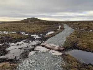
Continue around to a small building, from which point you must turn right to begin the slight climb to the summit. This once boggy path has been replaced with a well laid gravel path and is obvious to follow. You will soon see the slight rocky mound that marks a Bronze Age burial chamber and Blorenge summit.
From the summit, the gravel path continues in a southerly direction towards Foxhunters carpark, which is flanked by two large radio masts. At the car park turn right and join the small tarmac road. Follow this road for just a few hundred meters and then branch off to the right, along a grassy path to return to Keepers Pond carpark.
Did you know? The Keeper’s Pond was built in the early 19th century to provide water for Garn Ddyrys Forge. The gamekeeper of the Grouse moors lived in a cottage near to the pond and that’s where the name comes from.
2. A Long Blorenge Mountain Hike
- Starting Point: Keepers Pond Car Park on the B4246
- OS Explorer Map OL13
- Distance: 11km/7 miles
- Time: 4-5 hours
- Difficulty: Moderate-challenging
This is another great Blorenge circular walk, but this one does involve a lot more “up” and is therefore more challenging than the first option.
From the carpark, again head to the pond and follow the path to the left in a clockwise direction. At the far end of the pond the path continues in a northerly direction. This time, at the fork, branch off to the left following the stone sign for Govilon and Llanfoist.

This rocky path descends briefly before it levels off and meets the old Hill Tramroad. Turn right here, staying on the tramroad as it contours around the northerly end of the Blorenge. Keep your eye out for remains of the Blorenge’s tramroad tunnel.
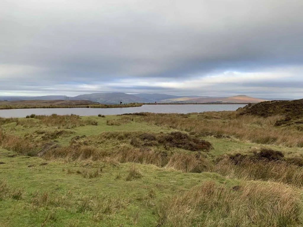
Continue around the eastern side of the hill until you reach a small wooded area with a lake in the middle. This glacial cwm is known as the Punchbowl, which is a Woodland Trust Nature Reserve. Take a moment to watch for a variety of birdlife at this man-made lake, before beginning the climb to the summit.
From the punchbowl take the trail to the left of the lake and ascend the lower path into the woods. Continue along this path until it joins the small road which leads to Foxhunter carpark. Turn right along the road and after 500m take a sharp right back onto a grassy path.
Climb steeply up the eastern side of the hill to reach a plateau. You are nearly at the summit! Follow the path as it turns left past a small building and climbs in a southerly direction towards the summit, on a well maintained gravel path.

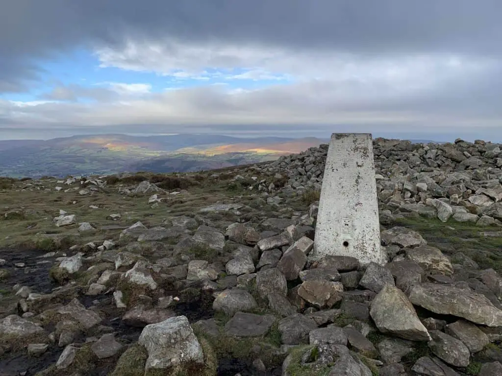
A small pile of rocks marks the summit with a trig point just beyond. From the summit continue along the gravel path towards the two radio masts located to one side of Foxhunter carpark. At the carpark turn right and again walk along the country road for a few hundred meters. Branch off the road to the right, along a grassy path to return to Keepers Pond carpark and the end of this circler walk.
Did you know? Blorenge mountain is thought to have inspired the hymn “All things bright and beautiful”. The line “the purple headed mountain, the river running by” is thought to reference Blorenge mountain and the river Usk


3. A Quick Walk To Blorenge Summit
- Starting Point: Foxhunters car park
- OS Explorer Map OL13
- Distance: 3km
- Time: 1 hour
- Difficulty: Easy
If you want to enjoy a short and easy walk to the summit of the Blorenge, then this is the walk for you! Branch off the B4246 road from Blaenavon, just before the Keepers Pond and take the small country road to Foxhunters carpark.
From Foxhunters carpark there is a well maintained gravel path that heads in a northerly direction, straight to the mountain summit. The trail is around 1.5km one way and has a gradual ascent of around 45m.
A small pile of rocks marks an ancient burial chamber and a trig point signifies the summit of Blorenge. From the summit enjoy views of Sugar Loaf and the valley beyond in one direction and views of the Bristol Channel in the other.
Did you know? Foxhunter’s carpark is dedicated to the famous showjumping horse, Foxhunter, who won Britain’s only gold medal in the 1952 Summer Olympics. Foxhunter is buried just off the trail close to the carpark and is marked by a plaque.
What To Pack For A Blorenge Mountain Walk
- Suitable clothing: warm layers and waterproofs
- Water, food, snacks: filtering water bottles are very handy for safely refilling in streams and rivers. You can read more about filtering water bottles in this guide. Psst! I’ve secured a deal for all readers of this website. Simply use the code WWG15 at checkout to get a 15% discount off all Water-to-go bottles and filters.
- Quality hiking boots or trail shoes are a must
- The relevant map and compass, and the ability to use them!
- A first aid kit for hiking
- GPS or mapping app: A great free app option is maps.me, although the free features have now become limited. I have an annual subscription to OS which means I have access to all UK OS maps on my mobile. I can definitely recommend it if you’re a regular hiker/walker.
These are just some of the essentials, but for a complete list of things to take on a hike in Wales, take a look at this guide!
Prefer not to walk alone? If you’re looking for a Mountain Leader to guide you on a mountain adventure, please contact me at [email protected] to discuss rates and availability.
Where to Stay in the Bannau Brycheiniog
The Bannau Brycheiniog/Brecon Beacons has several cute market towns and villages to use as a base for exploring the national park. There aren’t many large chain hotels but instead, you will find a selection of bed and breakfasts, pubs/Inns, glamping and camping opportunities.
As a central location, you can’t go far wrong with the town of Brecon. The beautiful Camden Lodge B&B offers exceptional service, with large, clean rooms that have delightful views over the hills. To experience the charm of a cosy, local pub try the Usk and Railway Inn at Sennybridge. This is a fabulous location for mountain bikers looking to get out in the hills.
If you’d prefer to be based near the Black Mountains in the east, opt for the The Bear which is an atmospheric old pub located in the small town of Crickhowell. In the west, Cwtch Bach is a gorgeous stone bricked holiday home perfect for exploring The Black Mountain region.
For luxury glamping ideas take a look at this guide to glamping in the Bannau Brycheiniog/Brecon Beacons.
Blorenge Walk Summary
The Blorenge is a hill in the Black Mountains region of the Brecon Beacons (Bannau Brycheiniog). It is a relatively small, rounded peak located between Abergavenny and Blaenavon. Blorenge mountain offers walkers a chance to enjoy fine views, a variety of wildlife and a glimpse into the areas industrial heritage.
There are several routes to enjoy a walk of the Blorenge, with options to suit all abilities. In this guide I outline three walking routes which range in difficulty and length. I provide brief trail descriptions, distances, times and starting locations for each.