
Last Updated on 15/11/2024 by Louise
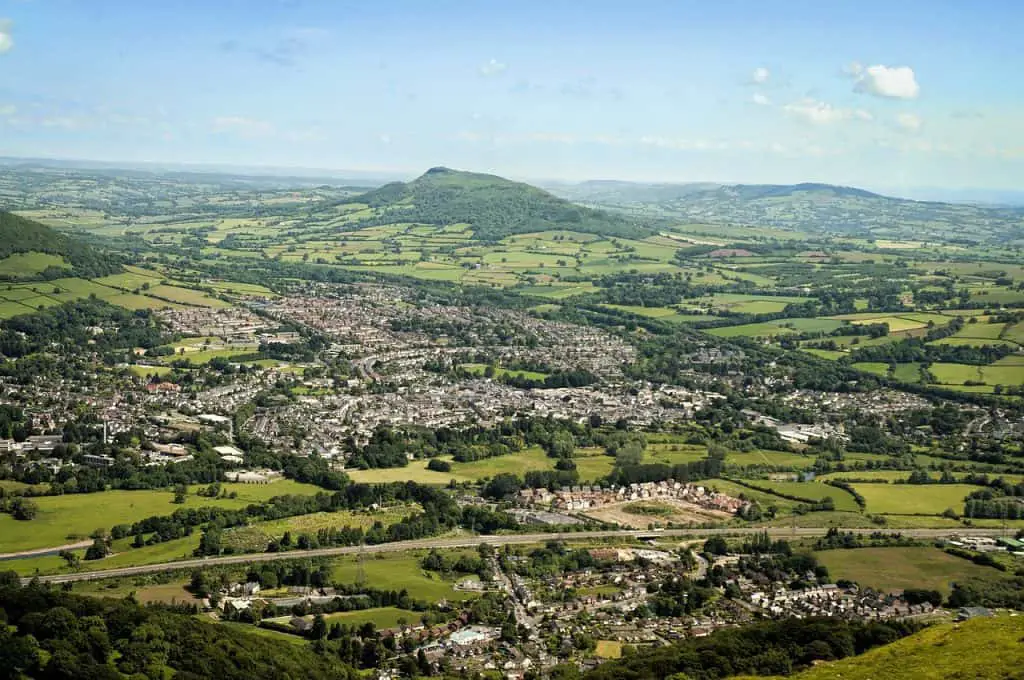
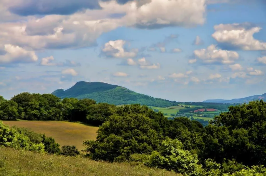
Skirrid Fawr, Ysgyryd Fawr in Welsh or simply the Skirrid to locals, is a small peak in the eastern area of the Brecon Beacons (Bannau Brycheiniog) known as the Black Mountains. At 486m (1594ft) and steeped in legend and folklore, Skirrid Fawr is a moderate 2-3 hour walk near Abergavenny in Monmouthshire.
This is a guide to hiking Skirrid from two different starting locations. I provide distances, times and a detailed description of each walk.
Disclaimer: Some links in this article are affiliate links, which means that if you purchase through them I receive a small commission, at no extra cost to you. This helps cover the cost of running this blog. Thanks for your support!
Skirrid Mountain
Skirrid mountain has a distinctive shape. It stands separated from the rest of the range, with one side hollowed out and a long ridge leading from it’s summit. On the summit there are ruins of an Iron Age Hill fort and a Medieval chapel dedicated to St. Michael.
There are actually two Skirrid mountains. Legend has it that Great Skirrid and Little Skirrid were created after the crucifixion of Christ. The mountain was so angered by the horrible event that it split and broke into two pieces. For this reason Skirrid Fawr is often known as Holy Mountain and also explains the Welsh name Ysgyryd Fawr which translates to Great Shattered.
The hollowed out mountain side was actually more likely caused by a landslide during the ice age!
Enjoy These Nearby Walks Next!
Guide To Skirrid Mountain Walks
Below I describe two walking options to reach Skirrid Fawr summit. One route approaches Skirrid from the north and the other from the south. They are both similar in distance and difficulty, however one has a long gradual walk to the top whereas the other has a short, steep climb to the top.
Route 1 requires a little more navigational skill than route 2. I like both of these routes but find I enjoy the views from the ridge better when I’m walking up it rather than walking down it, which means I slightly favour route 1. (Although you can obviously do route 2 in reverse!)
The OS map covering Skirrid walks is OL13, which you can buy here.
This is a video of a short out and back hike of Skirrid from the National Trust car park in the south.
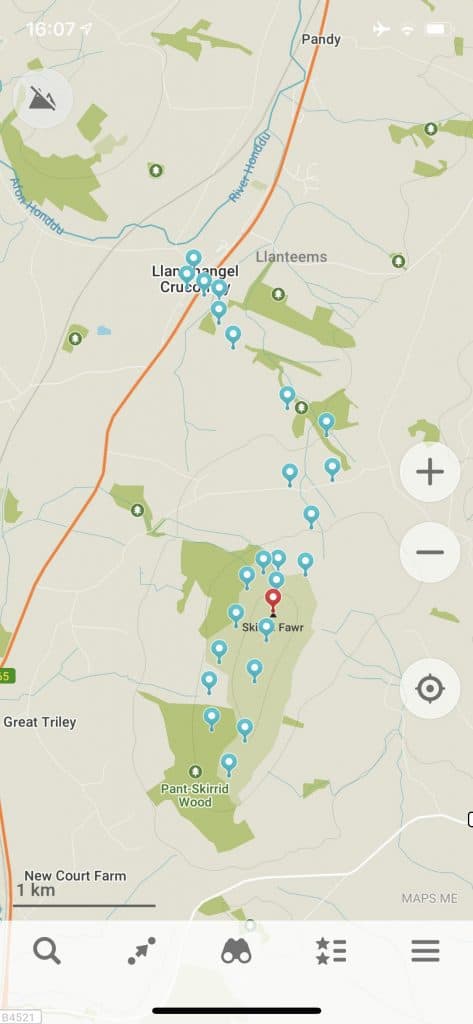
Route 1 – Ysgyryd Fawr from the North
Summary: A gradual ascent through fields, woods and along the ridge with a steep decent from the peak.
- Starting Location: Lay-by next to Saint Michael’s Church in Llanvihangel Crucorney
- Distance: 6.5km (4miles)
- Elevation gain: 320m(1050ft)
- Time: 3 hours
Directly opposite the church is an alleyway which leads to the A465. Carefully cross over this busy road and continue along the gravel road past Llanvihangel Court.
The gravel track then turns into a footpath. Keep an eye out for a wooden footpath signpost which directs you off the main track and across farmers fields. The path may not be well trodden so keep looking for stiles to signify your exit from the fields.
Around 2km into the walk you will be spat out onto a small country lane. Turn right here and walk along the road for around 350m. There is a stile on the lefthand side of the road which puts you back into the fields. Follow this path up to a crossroads at the base of Skirrid Fawr.
Turn right and contour around the western side of the mountain. This gradual uphill path takes you through the beautiful canopy of Pant Skirrid. Once on the south side of the mountain, turn left up a steeper section to begin climbing the ridge.
Enjoy surrounding views as you walk along the ridge which eventually brings you to the summit.
For the return journey exit the summit in a northerly direction for a short, steep descent back to the base of the mountain. Upon reaching the path which you used to contour the mountain earlier, turn right and continue back to the crossroads. At the crossroads turn left and simply retrace your footsteps back to the church.
After finishing your walk head to the Skirrid Mountain Inn for some well deserved hearty pub-grub or even spend the night if you’re brave enough. More about that below!
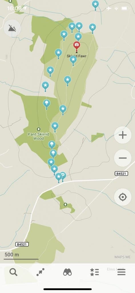
Route 2 – Skirrid Fawr from the South
Summary: A traverse around the base and steep climb to the summit followed by a gradual descent along the ridge.
- Starting Location: National Trust Car park on the B4521. (Pay and display)
- Distance: 5.6km (3.5miles)
- Elevation gain: 350m(1160ft)
- Time: 2.5-3 hours
This is the more well-known Skirrid walk advertised by the National Trust who own the mountain.
From the car park follow the signposted footpath towards Caer Wood. Cross through the gates and enter the woodland. At the top of the woods turn left at the gate with the big banner and follow the path that contours around the western side of the Skirrid.
Enjoy this leisurely stroll through the woods and around the hillside before it turns into a short, steep climb to the summit. At the wooden way marker turn right and take the path that heads directly up the hill.
The thigh burning climb is soon rewarded by the sight of a trig point which marks the summit. From you can enjoy fabulous views in all directions. Look out for the cone shaped hill of Sugarloaf to the west and the market town of Abergavenny to the south.
For the return journey follow the ridge which gently descends from the summit in a southerly direction. Turn left at the wooden way marker which soon rejoins the path used on the outbound route.
From this point simply retrace your steps back to the car park.
If you’d prefer to ascend the ridge, simply enjoy this hike in reverse.
The Skirrid Inn
Nearby you can find the Skirrid Mountain Inn which is reputed to be the oldest and most haunted pub in Wales. The Skirrid Inn is 900 years old with a fascinating and dark history.
Dating back to the Norman Conquests of the 11th century, the pub was once used as a courthouse and execution place, with evidence on the beams of where the hangman’s noose once laid. With so many reports of ghostly activities you can now reserve a spot on a ghost hunt. Would you dare spend a night here?!
What To Pack For A Skirrid Mountain Walk
- Suitable clothing: warm layers and waterproofs
- Water, food, snacks: filtering water bottles are very handy for safely refilling in streams and rivers. You can read more about filtering water bottles in this guide. Psst! I’ve secured a deal for all readers of this website. Simply use the code WWG15 at checkout to get a 15% discount off all Water-to-go bottles and filters.
- Quality hiking boots or trail shoes are a must
- The relevant map and compass, and the ability to use them!
- A first aid kit for hiking
- GPS or mapping app:A great free app option is maps.me, although the free features have now become limited. I have an annual subscription to OS which means I have access to all UK OS maps on my mobile. I can definitely recommend it if you’re a regular hiker/walker.
These are just some of the essentials, but for a complete list of things to take on a hike in Wales, take a look at this guide!
Prefer not to walk alone? If you’re looking for a Mountain Leader to guide you on a mountain adventure, please contact me at [email protected] to discuss rates and availability.
Where To Stay When Exploring the Black Mountains
As mentioned above, one option would be to stay at the Skirrid Mountain Inn. However, if you’re not so keen on things that go bump in the night there are plenty of options in nearby Abergavenny.
Abergavenny is a historic market town which has a fabulous food festival in September. Throughout the year you can enjoy Michelin Starred fine dining, at the famed Walnut Inn or for some wine tasting head to Sugarloaf Vineyard.
There are also many more walks to enjoy in the Black Mountains including Sugar Loaf, the Monmouthshire canal and my personal favourite, Waun Fach.
You can discover more about these Beacons walks in this handy guide.
Skirrid Fawr Walk Summary
Skirrid Fawr is a great short walk in the Black Mountains of South Wales and a top alternative to the more popular hill of nearby Sugar Loaf. In this guide I have outlined two walking routes to reach the summit of this small peak, both of which are similar distances and difficulties. Either of these routes will take 2-3 hours to complete and on clear days offer fabulous views of the area in all directions.
Join My Newsletter Today