
Last Updated on 15/11/2024 by Louise
The Elidir Trail is one of the finest walking trails of Waterfall Country in the Brecon Beacons (Bannau Brycheiniog). There are four official waterfalls to marvel at on a walk along the Elidir Trail, along with multiple cascades. The walking path is easy to follow and takes walkers on a journey through ancient woodland and past abandoned mines.
For the more adventurous hiker there is also a fifth, secret waterfall, although there is no way-marked path to this waterfall.
In this guide I describe 3 walking route options to enjoy the Elidir Trail waterfalls.

Disclaimer: Some links in this article are affiliate links, which means that if you purchase through them I receive a small commission, at no extra cost to you. Thank you! This helps cover the cost of running this blog and keep all resources free to access 🙂
The Elidir Trail
The Elidir Trail is an enchanting walk through a Celtic rainforest which follows the banks of two rivers. The trail is family friendly and, legend has it, provides access to a magical Fairy Kingdom.
There are two options when it comes to starting locations for the Elidir Trail, either from the village of Pontneddfechan or from a small car park called Pont Melin-fach. The walking terrain for each option is the same but starting from Pontneddfechan does make the walk around 2.5km longer.
Each starting point provides an out and back walk which takes in four beautiful waterfalls. The four waterfalls on this walk are Sgwd Gwladys, Sgwd-y-Bedol, Sgwd Ddwli Uchaf and Sgwd Ddwli Ichaf. From Sgwd Gwladys there is an unofficial trail which takes hikers on an adventure of river crossings to find a fifth waterfall, Sgwd Einon Gam. This trail is not suitable for children.

Did you know? Elidir was a young monk who ran away from his Abbey after being treated cruelly. Welsh legend has it that Elidir was taken in by the Fairy folk and that the entrance to their Fairy Kingdom lies here, along the banks of the river.
1. The Elidir Trail from Pontneddfechan
- Distance: 7km round trip
- Starting Point: Park near the Angel Inn in Pontneddfechan village
- Time: 2 – 3 hours
This walk begins near the Angel Inn, in Pontneddfechan village. There are public toilets at the start of the trail. Walk through the iron gate and you will see an information board to mark the start of the path.
The initial walk alongside the Afon Nedd Fechan (Neath River) to Sgwd Gwladus follows an old horse and cart track and is relatively straight and level. This, along with old silca mines dotted along the river, provides a clue to the areas industrial past.
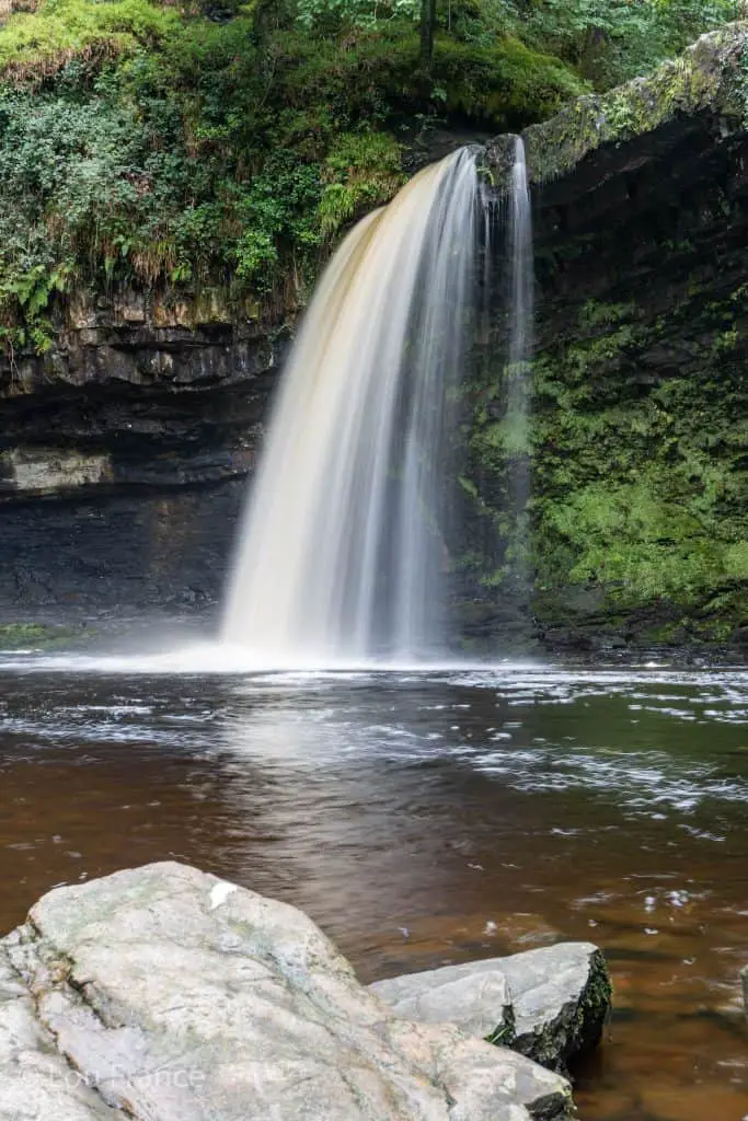
Walk along the river, past several cascades before crossing over a wooden bridge. Turn left after crossing the bridge to walk along the right-hand side of the river. Shortly afterwards you will reach Sgwd Gwladus (Lady’s Fall) which, if you’re prepared to get your feet wet, you can walk behind via precariously placed stepping stones.
To continue the walk, from Sgwd Gwladus return to the bridge and take the trail along wooden planks to the left. This is signposted for Pont Melin-fach and the path from here becomes steeper and narrower. Follow the Nedd Fechan river towards Pont Melin-Fach to see an impressive trio of waterfalls. This path is very muddy and slippery after heavy rainfall so please take care as you walk.
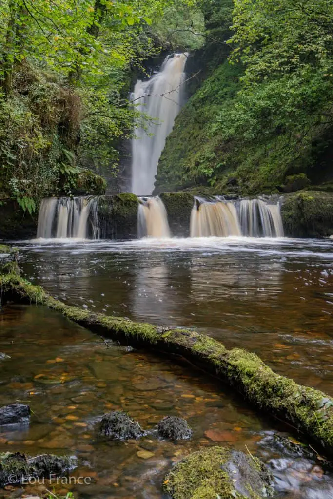
First you will see Sgwd-y-Bedol or Horseshoe Falls. I always think of this waterfall as a mini Victoria falls! Next, if the river level is low and not flowing fast, you can walk along the river bank to the next waterfall, Sgwd Ddwli Isaf or Lower Gushing Falls. Be warned this bedrock is very slippery!
Sgwd Ddwli Isaf has a smaller waterfall below its pool and again, if the water levels are low you can climb up the left hand side of the ledge to get close to the main waterfall.
To see the fourth waterfall on this walk you will need to retrace your steps to Sgwd-y-Bedol and rejoin the main trail. From this path you can view the top of Sgwd Ddwli Isaf. Continue along this path until you reach Sgwd Ddwli Uchaf or Upper Gushing Falls on your right.
Take the side path to get down to the rivers edge and see the waterfall up close. Once you have spent time admiring this final waterfall, retrace your route to Pontneddfechan to finish.

2. The Elidir Trail from Pont Melin-fach
- Distance: 4.5km round trip not including secret falls.
- Starting Point: Pont Melin-fach car park on Heol Calch, SA11 5UR
- Time: 2 hours
This walk is shorter than the first option but provides access to the same waterfalls.
The car park at Pont Melin-fach is small and only provides parking for a small number of cars, so this might be a consideration for your walking route choice on weekends or bank holidays.
In the car park there are information boards which mark the start of the walk. Follow the path for around 15 minutes, then on the left you will see the first waterfall Sgwd Ddwli Uchaf. A small side trail allows you to get up-close to this wide waterfall.
Rejoin the main path to continue downstream. Shortly afterwards you will see Sgwd Ddwli Isaf from above, but continue downstream, along the path to get a better view of this waterfall from river level. A little further along the path you will come to a small wooden bridge. Branch off to the left before crossing the bridge.
Here you can see the two tiered, Sgwd-y-Bedol (Horseshoe Waterfall) and looking back up-stream you can now see Sgwd Ddwli Isaf from river level. If water levels are low, walk up along the (slippery) river bedrock to get a closer viewing of Sgwd Ddwli Isaf.
To continue the walk, re-join the main trail, cross the bridge and walk downstream until the Nedd Fechan river joins the Afon Pyrddin. This path is narrow and can be slippery when wet so please take care. Follow the path around to the right, ignoring the wooden bridges which cross over their respective rivers.
Just a few hundred meters long the right hand side of the River Pyrddin, you will see the final waterfall of the walk, Sgwd Gwladys.
If you’re feeling brave you can hop along the rocks to walk behind Sgwd Gwladys. However, if you want a great experience of walking behind a waterfall, I recommend visiting Sgwd-Yr-Eira on the Four Falls Trail.


3. How to reach the Secret Waterfall on the Elidir Trail (Sgwd Einion Gam)
- Distance: 6km round trip
- Starting Point: Park near Angel Inn in Pontneddfechan village
- Time: 2 – 4 hours
There is a secret waterfall, Sgwd Einion Gam, which can be accessed from Sgwd Gwladys. However, be warned, this is not an official trail and is not marked on a map! Attempt this route at your own risk.
Since this trail starts at Sgwd Gwladys, you can begin this walk at Pontneddfechan or Pont Melin-fach. There is more parking at Pontneddfechan so I would suggest walking from there, however, if you want to see all five waterfalls in one hit, start from Pont Melin-fach.
At Pontneddfechan, take the Elidir Trail and follow the marked path to Sgwd Gwladus (see route 1 for details). From Sgwd Gwladus, climb up the bank to the right-hand side of the waterfall. This leads to a meadow above the falls. Initially there is a well- trodden trail to follow along the right hand side of the river, but this soon gives way to river crossings and bush-whacking!
This trail crosses the river twice and it should be fairly obvious when this is necessary. The first crossing comes at a bend in the river, where a cliff of limestone blocks your path. The path taken to cross the river is one of personal preference. Just look for a route where the water isn’t too deep or fast moving.
Follow along the left hand side of the river for a few hundred meters before you are forced to cross once again. After the second river crossing, the path rises up above the river along a steep exposed edge. It’s not for the faint hearted, so attempt this path at your own risk. If you feel more comfortable you could walk upstream in the river instead.
The path then drops back down to the rivers edge and you will see Sgwd Einion Gam straight ahead of you.

This waterfall has a tall main fall (second highest in South Wales in fact!), with a smaller ledge of cascades below. To get a closer look at the main waterfall and pool, climb up onto the ledge on the right hand side of the river. To see the main waterfall with the cascades below in full view, you will once again have to get those feet wet and walk into the middle of the river.
To complete this adventure retrace you steps back to Sgwd Gwladys and to Pontneddfechan beyond.
If you liked this walk you might also enjoy the walk to discover Pen y Fan’s secret waterfall. Learn more here!
Warning: Wellies/waders are required for this walk or, if water levels are high, be prepared to get thigh deep! Do not attempt this walk in winter or after heavy rain.
Read Related Articles
- 9 Beautiful Walks In Waterfall Country
- The Best Mountain Walks In The Brecon Beacons
- 5 Top Walks In The Gower
- 35 Amazing Things To Do In South Wales
The Legend of Gwladus and Einion – The Welsh Romeo and Juliet
The most beautiful daughter of King Brychan of Brycheiniog, was Princess Gwladus. Gwladus fell in love with a peasant called Einion but her father wouldn’t allow them to get married. Distraught at the prospect of living without her true love, Gwladus jumped into the icy cold waters of the Afon Pyrddin and was swept away. In her wake a beautiful waterfall formed – Sgwd Gwladus.
Einion however, had managed to persuade her father allow the marriage as long as he gained wealth and status. He followed her to the river to share the good news, but alas he was too late. Einion’s heart was broken and in his grief, he too threw himself into the raging river.
The ground shook and a second waterfall was formed – Sgwd Einon Gam. (Source).
Did you know? The new (old) Welsh name for the Brecon Beacons is Bannau Brycheiniog. Bannau meaning peaks and Brycheiniog meaning the kingdom of (King) Brychan. It is pronounced Ban-eye Brih-chein-ee-og where the ch is soft like loch.
Where to Stay in the Bannau Brycheiniog
The Bannau Brycheiniog/Brecon Beacons has several cute market towns and villages to use as a base for exploring the national park. There aren’t many large chain hotels but instead, you will find a selection of bed and breakfasts, pubs/Inns, glamping and camping opportunities.
As a central location, you can’t go far wrong with the town of Brecon. The beautiful Camden Lodge B&B offers exceptional service, with large, clean rooms that have delightful views over the hills. To experience the charm of a cosy, local pub try the Usk and Railway Inn at Sennybridge. This is a fabulous location for mountain bikers looking to get out in the hills.
If you’d prefer to be based near the Black Mountains in the east, opt for the The Bear which is an atmospheric old pub located in the small town of Crickhowell. In the west, Cwtch Bach is a gorgeous stone bricked holiday home perfect for exploring The Black Mountain region.
For luxury glamping ideas take a look at this guide to glamping in the Bannau Brycheiniog/Brecon Beacons.
Summary of Walking the Elidir Trail
The Elidir Trail offers a beautiful selection of waterfalls in the Brecon Beacons (Bannau Brycheiniog) to explore. In this guide I have outlined three walking route options to explore these waterfalls. There are walking options for families as well as a hiking option for the more adventurous.
Be sure to check the weather before you leave and pack accordingly….
- Suitable clothing: warm layers and waterproofs
- Water, food, snacks: filtering water bottles are very handy for safely refilling in streams and rivers. You can read more about filtering water bottles in this guide. Psst! I’ve secured a deal for all readers of this website. Simply use the code WWG15 at checkout to get a 15% discount off all Water-to-go bottles and filters.
- Quality hiking boots or trail shoes are a must
- The relevant map and compass, and the ability to use them!
- A first aid kit for hiking
- GPS or mapping app:A great free app option is maps.me, although the free features have now become limited. I have an annual subscription to OS which means I have access to all UK OS maps on my mobile. I can definitely recommend it if you’re a regular hiker/walker.
These are just some of the essentials, but for a complete list of things to take on a hike in Wales, take a look at this guide!
Enjoy these nearby hikes


Join My Newsletter Today!
Recent Posts
11 Best Waterfalls in South Wales (With Videos & Parking Locations): 2026 Edition
South Wales is a waterfall lover’s paradise. With ancient woodland, dramatic gorges, and mountain-fed rivers, this region boasts some of the UK’s most spectacular waterfalls. Tucked away in the...
Athens' modern-day charm might captivate many tourists, but its historic side, represented by the glorious Acropolis, is unmatched. This beautiful landmark is a powerful reminder of ancient history...