
Last Updated on 14/12/2025 by Louise
The Glyderau (commonly called the Glyders) is a mountain range in Eryri/Snowdonia National Park. The range takes its name from the two highest peaks in the range – Glyder Fawr (1001m) and Glyder Fach (994m).
The Glyderau range includes five of the Welsh 3000s, which are peaks in Wales standing over 3000ft in height. In the Glyderau, these peaks are Glyder Fawr, Glyder Fach, Y Garn, Elidir Fawr and Tryfan.
All 11 peaks of the Glyderau can be traversed in one (very) long day, however there are far more enjoyable hiking routes that instead just take in a few peaks in the range.
| Glyder Fawr is a mountain in Eryri/Snowdonia National Park which is 1001m tall. It is the tallest peak in the Glyderau mountain range and is famous for it’s jagged rock formations. There are multiple hiking and scrambling routes to the summit of this mountain. |
Glyder Fawr & Glyder Fach
Whilst, as the highest mountain in Wales, Yr Wyddfa/Snowdon attracts most of the visitors in the Snowdonia mountains, the neighbouring peaks in the Glyderau range offer a more unique experience.
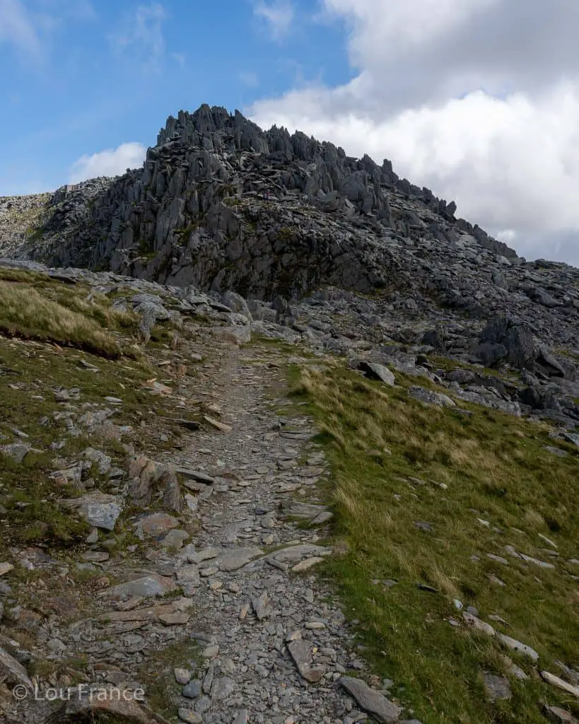
Glyder Fawr and Glyder Fach are peaks with spectacular, other worldly rock formations which provide hiking and scrambling days that live long in the memory.
Glyder (deriving from Gludair) is a Welsh word which translates to pile or heap of rocks. In Welsh Fawr means big and Fach means small, so these peaks translate to big pile of rocks and small pile of rocks. Once you’ve walked on top of these two incredible mountains you’ll understand how fitting these names really are!
So how do you pronounce Glyder Fawr? Phonetically Glyder Fawr sounds like Glid-dur va-oor (where the r is rolled at the end)
To learn more about Welsh place names and how to pronounce them, take a look at this post!
There are fabulous 360 views from the summits of Glyder Fawr and Glyder Fach, with the Snowdon massif to the southwest and the Carneddau and Anglesey to the north.
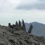
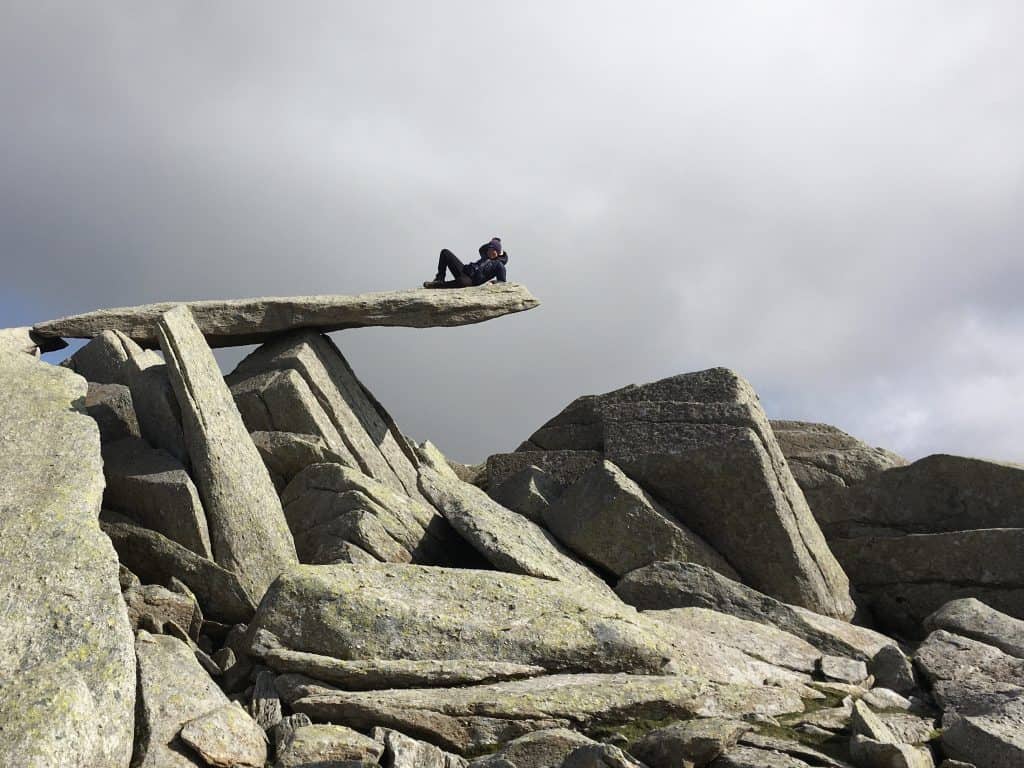
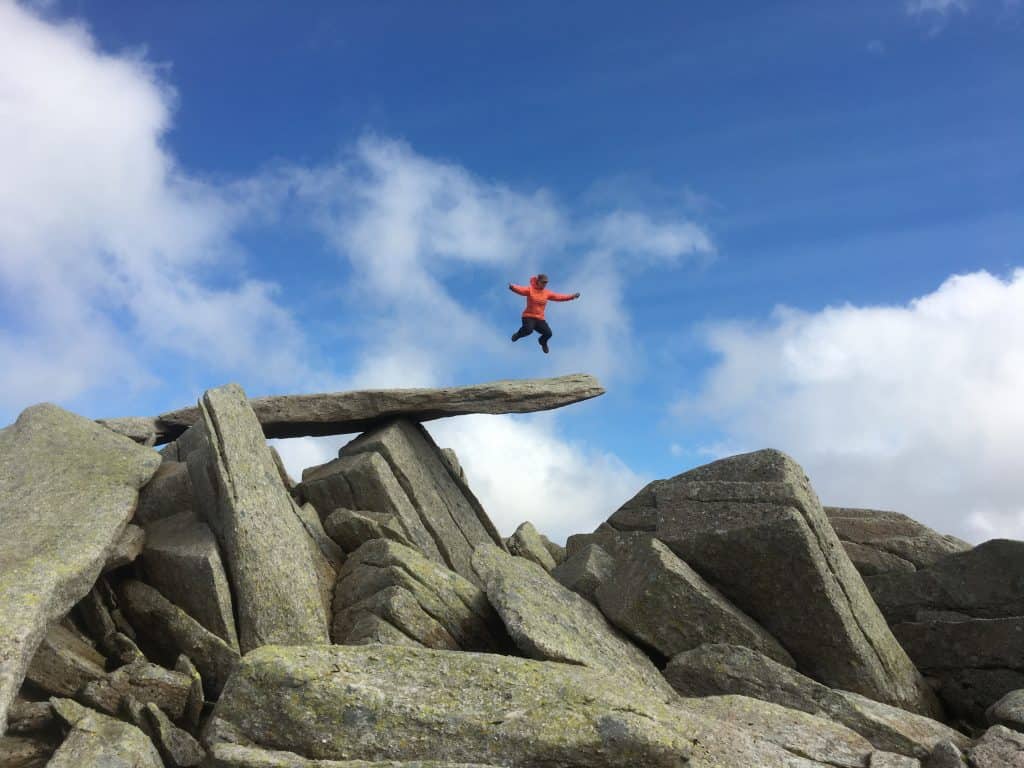
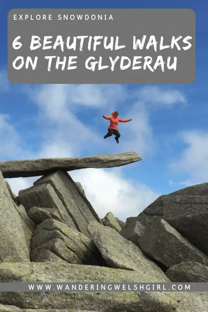
Found on a rocky plateau, close to the summit of Glyder Fach is the iconic Cantilever Stone. As well as providing a great spot for a break, the stone also offers a great opportunity for some fun photographs.
Castell y Gwynt
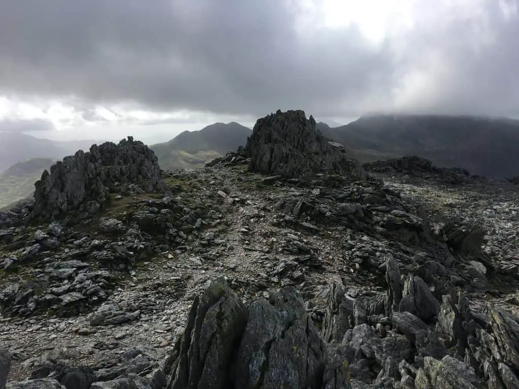
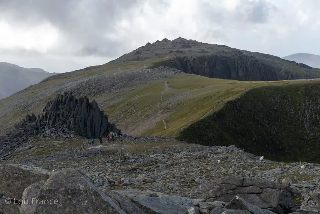
Located between the two peaks of Glyder Fawr and Glyder Fach is Castell y Gwynt or Castle of the Wind. Castell y Gwynt is just a short walk from Glyder Fach summit but is actually the child summit of Glyder Fawr. It was reclassified as a Nuttall in 2007 but since it is not a Hewit, it is not included in the Wales 3000s.
This giant rock pinnacle has shards of rock that rise up from the ground like spines on a dragons back. These rocky spines create quite a foreboding atmosphere on wet and windy days, but in a practical way they actually provide great shelter from the harsh Welsh elements. It offers a fun and relatively easy scramble en route to Glyder Fach.
Fun Fact: Castell y Gwynt & The Cantilever Stone feature in Walt Disney’s film Dragonslayer and marks the entrance to the Dragon’s lair!
6 Beautiful Walks to Glyder Fawr & Glyder Fach
There are many walking routes that take in the peaks of Glyder Fawr and Glyder Fach. There are also numerous scrambles onto the top of the Glyderau but I’ve only included one in this list.
For information on scrambles in the Glyderau and the rest of Snowdonia I recommend this book.
Below I provide information about 6 of the best walking routes to Glyder Fawr and Glyder Fach. These walks can be combined in various ways and completed in either direction so feel free to mix and match!
1. Glyder Fawr & Glyder Fach Loop Walk via the Devil’s Kitchen & Cwm Tryfan
- Distance: 12.5km
- Elevation Gain: 855m
- Time: 5-6hrs
- Starting Point: A5 near Glan denau
- Map: OS Explorer OL17
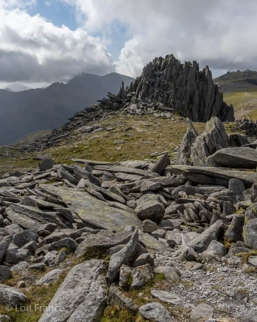
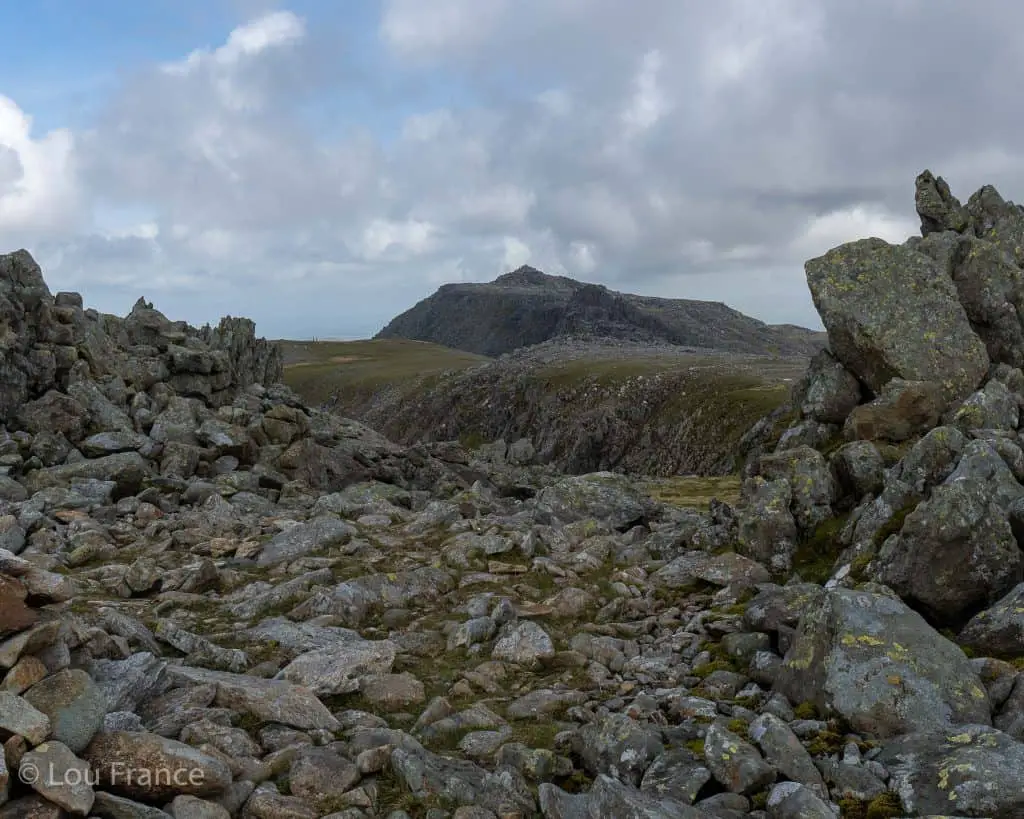
This a great option for a scenic Eryri loop walk since it incorporates many beautiful views along the way, such as Cwm Idwal, the Devil’s Kitchen and Glyder Fawr and Fach.
This hike starts from a lay-by on the A5 near Glan Denau. The first section is possibly the worst part of this route as you must walk the length of Llyn Ogwen along the A5.
From the Ogwen Visitor centre the path starts proper as it ascends into the picturesque Cwm Idwal. Passing around the shore of Llyn Idwal the next stage of the walk is to climb up alongside the Devil’s Kitchen to the plateau above.
For more information on hikes involving the Devil’s Kitchen, see this guide.
The fun certainly gets put on hold here as there is a loose scree ascent from Llyn y Cwn to the summit of Glyder Fawr. This is a tedious slog however the views in all directions from the top are well worth the effort.
In good weather it’s a short and relatively straight forward walk from Glyder Fawr to Castell y Gwynt. Pick your route up through the rocks of this incredible rock formation before continuing onto the summit of Glyder Fach.
If you enjoy climbing around on the big boulders it is possible to climb to the top of Castell y Gwynt, where fabulous views will await you. (Weather premitting obviously ;))
After a well earned break at the Cantilever Stone near Glyder Fach, take the easy path off the summit which avoids the grade 1 scramble of Bristly Ridge. This path leaves the summit in an easterly direction and joins up with the Miners Track briefly for a steep descent into Cwm Tryfan. However, turn off this path to the right to avoid ascending back up to Bwlch Tryfan.
Instead continue your decent down into the valley, skirting the base of Tryfan’s east face. This path will take you all the way back to the A5, after passing through Gwern Gof Uchaf Campsite.
If you like this content consider giving me a follow on social media
2. Glyder Fawr & Glyder Fach Loop via Devil’s Kitchen & Llyn Bochlwyd
- Distance: 8km
- Elevation Gain: 855m
- Time: 5-6hrs
- Starting Point: Ogwen Visitor Centre (paid parking)
- Map: OS Explorer OL17
This route is similar to the one above, differing only in the final decent and the starting location. Parking near Ogwen Visitor Centre is quite limited which is why you might prefer the option above. This walk also removes the need to walk along the A5 at the start of the walk and is therefore slightly shorter.
As in the route above, from the Ogwen Visitor Centre ascend to Cwm Idwal and Glyder Fawr via the Devil’s Kitchen. This is the shortest route to the summit of Glyder Fawr and takes around 3 hours. Continue onto Castell y Gwynt, Glyder Fach and the Cantilever Stone.
Again take the easier path off Glyder Fach to the east, before joining up with the Miner’s Track. Descend slightly into Cwm Tryfan but this time continue along the Miner’s Track to climb back up to Bwlch Tryfan.
Climb over the stile but rather than ascending Tryfan to your right, continue down the path towards Llyn Bochlwyd. Continue past the lake and across the river on a path which leads all the way down to Ogwen Visitor Centre.
If you’re feeling energetic this route could be extended to include the neighbouring peak of Y Garn from Llyn Idwal at the start of the hike. This would add just under 2km of distance and around 200m of ascent and descent to the route.
For a complete guide to hiking Y Garn via the Devil’s Kitchen, see this post.
As well as having epic mountain walks, Eryri is also blessed with beautiful waterfall walks. Discover the prettiest ones in this post!
3. Cwm Bochlwyd Horseshoe (Tryfan & Glyder Fach Scramble)
- Distance: 6.5km
- Elevation Gain: 820m
- Time: 7-8hrs
- Starting Point: Lay-by A5
- Map: OS Explorer OL17
The Cwm Bochlwyd Horseshoe is an epic Eryri adventure that is probably only surpassed by the Snowdon Horseshoe. This short loop consists of three grade 1 scrambles with moderate exposure. This route is recommended for experienced hikers/scramblers only.
This hike begins from the A5 lay-by at the base of Tryfan. The route climbs up Tryfan’s north ridge, passing the infamous cannon rock and the North Tower along the way. At the summit of Tryfan sit two monolith rocks known as Adam and Eve (Siôn and Siân)
In order the gain the “Freedom of Tryfan” brave hikers are required to leap the 1.2m gap between these two exposed pillars. Try it if you dare!
Descending down Tryfan’s south ridge into Bwlch Tryfan, you are now presented with the next scramble, Bristly Ridge. The more interesting route along Bristly Ridge is via Sinister Gulley.
Once above the gulley and past the Great Pinnacle, the scramble is then complete and there is a straightforward path first to the Cantilever Stone, and then to Glyder Fach summit itself.
Continue along from the summit towards Castell y Gwynt. The path climbs down boulders to the left of Castell y Gwynt, before skirting around the base and onto the final challenge.
The third and final scramble of the day is a descent along Y Gribin ridge. This is again a grade 1 scramble but the trickier sections can be easily by-passed by avoiding the ridge proper.
Once at the bottom of the ridge, pass by the north end of Llyn Bochlwyd and follow the path down alongside the river. Once on the plateau branch right at the fork, off the main path to head back to the A5.
For full descriptions of the these scrambles, check out the Scrambles in this Snowdonia guide book.
4. Glyder Fach Walk from Capel Curig
- Distance: 18.5km
- Elevation Gain: 970m
- Time: 9hrs
- Starting Point: Capel Curig car park
- Map: OS Explorer OL17
Aside from the peak of Glyder Fach and the walk through Cwm Tryfan, you will likely have this walk all to yourself. From the car park behind Joe Browns in Capel Curig, turn right onto the lane and follow it to the farm house, before taking the path onto open countryside.
Here begins the long gradual ascent along the Glyderau ridge. First you will ascend the minor top of Cefn y Capel, followed by the easternmost summit in the range of Gallt yr Ogof.
There is a small descent onto boggy ground before climbing up to Y Foel Goch. Descend the peak and cross the plateau past Llyn Caseg-fraith, before beginning the ascent of Glyder Fach. The path briefly crosses with the Miners track and just 200m on from this point, there is a rock cairn which marks the decent to Cwm Tryfan. Remember this for your return journey.
Here the path starts to get rockier as you make the final push to the summit. Enjoy photo ops on the Cantilever Stone and make the short walk west for views of Castell y Gwynt.
Retrace your steps back down Glyder Fach to the rock cairn. Take the steep path down to the left. Again briefly join the Miners Track, (which is heading for Bwlch Tryfan) before taking the path off to the right, down into Cwm Tryfan.
Follow this path to descend around the base of Tryfan and on towards Gwern Gof Uchaf campsite. Here turn right onto the bridleway. This bridleway skirts the Glyderau range all the way back to Capel Curig and the car park where you began.


5. Glyder Fawr & Glyder Fach Walk from Pen y Pass
- Distance: 9km
- Elevation Gain: 750m
- Time: 4-5hrs
- Starting Point – Pen y Pass; Finishing Point – Pen y Gwrd Hotel
- Map: OS Explorer OL17
From a navigational point, this route is a little more challenging than the other walks since the trail is not always obvious. However, aside from the peaks, the trails will be much quieter than those on the Ogwen Valley side.
Top Tip: Parking at Pen y Pass is limited (A nightmare!) and needs to be pre-booked in the Summer months. Instead, consider taking the Sherpa Bus from Llanberis, Nant Peris or Betws y Coed (or wherever you might be staying). This also means that once you finish at Pen y Gwrd Hotel you can enjoy a post hike pint, before jumping on the bus back your hotel – perfect! Get prices and timetable here!
From Pen y Pass car park, cross the road and pick up the path to the left of the Youth Hostel. Cross the boggy ground and follow the path in a northwesterly direction. You will soon see Llyn Cwmffynnon on your right hand side.
Then begins the climb of Glyder Fawr along it’s shoulder. The path here can be easily lost but just keep going up until you reach the unmistakeable rocky summit of Glyder Fawr.
In good weather the route from Glyder Fawr towards Glyder Fach is quite obvious, however in poor visibility map and compass work maybe required.
Skirt around the right side of Castell y Gwynt before clambering up a bouldery path to the summit. From here it’s just a short walk onto the summit of Glyder Fach, with the Cantilever Stone just beyond.
After some photo fun on the Cantilever Stone it’s time to start the descent. The route to Bristly Ridge is marked with a cairn but instead, bear off to the right to pick up a much gentler path off the summit.
Once at the bwlch this path joins up with the Miners Track. Turn right onto the Miners Track and follow this all the way down to your finishing place at Pen y Gwrd Hotel.
6. Glyder Fawr & Glyder Fach Walk from Nant Peris
- Distance: 11km
- Elevation Gain: 880m
- Time: 5-6hrs
- Starting Point – Cwm Glas Bach Guesthouse on A4086; Finishing Point – Pen y Gwrd Hotel
- Map: OS Explorer OL17
Consider this walk if you’d like to escape the crowds of Ogwen Valley and, aside from the summits, have the trail all to yourself.
The start of this route is around 1km beyond Nant Peris, near the Cwm Glas Bach Guesthouse. The path ascends in a northeasterly direction alongside the Afon Las. It climbs quite steeply until it levels off and reaches the saddle.
Walk around Llyn y Cwn before embarking on the loose scree ascent of Glyder Fawr’s northwest face. It’s a steep slog to the summit, however you will be rewarded with fabulous views of the Snowdon Massif (weather permitting!)
The route now continues along to Glyder Fach via Castell y Gwynt, and descends via the Miner’s Track to Pen y Gwrd Hotel (as described in the route above).
Once finished consider using the Snowdon Sherpa Bus to return to your starting location.
What To Take On A Glyderau Hike
Before you attempt any of these Glyderau hiking trails make sure you are properly prepared with both equipment and knowledge.
Check the weather forecast beforehand and then decide if the route is right for you on that day. Several of these routes have exposed edges and steep drops, which can be treacherous in wet, windy and foggy conditions.
Consider hiring a guide if you’re unsure.
Once you have chosen your route, make sure you have all the equipment you need. Here is a list of basic equipment needed to enjoy these fabulous Glyderau walks.
- Suitable clothing: warm layers and waterproofs
- Water, food, snacks: filtering water bottles are very handy for safely refilling in streams and rivers. You can read more about filtering water bottles in this guide. Psst! I’ve secured a deal for all readers of this website. Simply use the code WWG15 at checkout to get a 15% discount off all Water-to-go bottles and filters.
- Quality hiking boots or trail shoes are a must
- The relevant map and compass, and the ability to use them!
- A first aid kit for hiking
- GPS or mapping app:A great free app option is maps.me, although the free features have now become limited. I have an annual subscription to OS which means I have access to all UK OS maps on my mobile. I can definitely recommend it if you’re a regular hiker/walker.
These are just some of the essentials, but for a complete list of things to take on a hike in Wales, take a look at this guide!
Where To Stay On a Glyder Fawr Hike
Ogwen Valley
Most Glyderau hikes start in the Ogwen valley. If you want to keep things cheap and basic try Gwern Gof Uchaf campsite. If you prefer glamping try Gwern Gof Isaf. These two campsites are located a few miles from each other and are easy to confuse, so be sure to double check directions before you set off.
Llanberis
Idan House is a great little BnB in Llanberis which makes it ideal for starting a hike from Nant Peris. You could spend a few days extra in Llanberis, where you can visit the Lone Tree and Dolbadarn Castle or take a trip on the Snowdon train.
Whilst in Llanberis be sure to visit the recently re-opened Pete’s Eats for a proper mug of tea and a hearty breakfast!
Capel Curig
Capel Curig is the best place to stay to enjoy walk number 4. There is a fabulous hostel just outside the village called The Rocks which is the perfect budget option.
Hiking Glyder Fawr & Glyder Fach Summary
Glyder Fawr and Glyder Fach are the two highest peaks in the Glyderau (Glyders) range that are the location for several exciting UK hikes. There are multiple routes to summit these two mountains, ranging from long low-intensity walks to short technical scrambles.
Most paths start in the Ogwen Valley however there are other routes originating in Capel Curig, Pen y Pass and Nant peris. In this post I wanted to share 6 of the best Glyderau walking routes and provide some inspiration for your next mountain adventure!
If you’d like to learn about more hikes in Snowdonia National Park, take a look at this guide!
Like it? Pin it for Later!
Join my Newsletter Today!
Recent Posts
11 Best Waterfalls in South Wales (With Videos & Parking Locations): 2026 Edition
South Wales is a waterfall lover’s paradise. With ancient woodland, dramatic gorges, and mountain-fed rivers, this region boasts some of the UK’s most spectacular waterfalls. Tucked away in the...
Athens' modern-day charm might captivate many tourists, but its historic side, represented by the glorious Acropolis, is unmatched. This beautiful landmark is a powerful reminder of ancient history...