
Last Updated on 29/03/2026 by Louise
Mount Snowdon or Yr Wyddfa in Welsh, is located in Snowdonia National Park (Parc Cenedlaethol Eryri) in North Wales. At 1085m (3560ft) Mount Snowdon is the highest mountain in Wales and is home to the highest visitor centre in Wales – Hafod Eryri. It’s also the only major UK peak that has a train running to its’ summit.
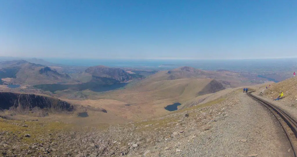
The 360 degree views from Snowdon’s summit are breathtaking and on clear days can stretch as far as Ireland. Mountain views like these are best savoured after they have been earned, and this can be done through hiking to the top.
There are several ways to get to the top of Yr Wyddfa (Snowdon). Having hiked to the top more times than I can count as Mountain Leader and as an Eryri Ambassador, I wanted to put together this helpful guide so you could decide which Snowdon route is right for you.

Disclaimer: Some links in this article are affiliate links, which means that if you purchase through them I receive a small commission, at no extra cost to you. This helps cover the cost of running this blog. Thanks for your support!
The Six Snowdon Routes at a Glance
There are six established Mount Snowdon walking routes to choose from. These Snowdon paths are the Pyg rack, Miners Track, Llanberis Path, Watkin Path, Snowdon Ranger Path and Rhyd Ddu Path. Each trail differs in length and difficulty.
The easiest Snowdon route is the Llanberis Path. Although this trail is not the shortest, it is easy to navigate and is the busiest Snowdon path. The most difficult Snowdon route is the Watkin Path as this requires some scree-scrambling and has the biggest elevation gain.
Here are the six Snowdon walking routes which outlines the main highlight:
- The Snowdon Ranger Path – a good Snowdon walk for avoiding the crowds
- Pyg Track – the Snowdon path with the least elevation gain
- Miners Track – the best Snowdon route for views
- Llanberis Path – the easiest walk up Snowdon for beginners
- Watkin Path – the most challenging Snowdon route
- Rhyd Ddu – the quietest Snowdon trek
These Snowdon walking routes can also be combined in any number of ways to make great circular routes. The Miners Track and Pyg Track are often combined to make a loop, since they both start at the same location.
However, the issue of finishing at a different location is negated if using the Snowdon Sherpa (Sherpa’r Wyddfa). This bus service travels around the foot of Mount Snowdon, creating a valuable link between the six main Snowdon trails. A full day pass costs £6 and runs every 15 minutes on weekends in the summer.
For more experienced hikers there is also the Snowdon Horseshoe, which takes in the peaks of Y Lliwedd, Yr Wyddfa, Garnedd Ugain and Crib Goch. This hike is considered the best ridge walk in Wales, arguably in the UK. This route involves scrambling and has very exposed edges. It is not suitable for beginners.

In 2022 a vote by the Snowdonia National Park Committee determined that Snowdon and Snowdonia should be called by their Welsh names in both Welsh and English context. This means that Snowdon will be known as Yr Wyddfa and Snowdonia as Eryri. In this guide I will use both interchangeably.
Check the weather forecast for your Snowdon hike here.
Map: Starting Locations For Every Hike
The 6 trails to the summit of Snowdon are marked out on Google Maps. I’ve pinned the starting locations on the map below for each of the hikes described in this guide.
Official Yr Wyddfa Walking Route App
Did you know you can get a free, GPS enabled app which can help guide you along the six main walking routes? This app has been developed by the National Park Authority to help visitors to the area with their navigation to the summit of the UK’s busiest peak.
This is the link to the app – Llwybrau’r Wyddfa.
A Guide To The Best Mount Snowdon Paths
1. The Snowdon Ranger Path
- Distance: 13km/8 miles around trip
- Time: 6 – 7 hours
- Elevation Gain: 936m/3071ft
- Starting Point: Car park next to YHA Snowdon Ranger
- Pros: The path is quiet and easy to follow
- Cons: The views are not as dramatic as some of the other trails
This quieter Snowdon trail climbs the west side of the mountain, and with good weather the summit will be visible for most of the walk. This is thought to be the oldest path to the summit of Yr Wyddfa and offers views. This is also the trail I took on my first ascent of Snowdon and I still hold fond memories of that hike.
From the car park opposite the Ranger Youth Hostel, cross the road and follow the stone pillar marked with “Ranger Path”. Cross over the railway track, past Llwyn Onn farmhouse and onto a well established path which zig zags steeply out of the valley floor.
Follow the path along a flatter section past the lake, before it makes a steep ascent on to the ridge. Once on the ridge the Ranger Path crosses the railway line to arrive at Bwlch Glas, where several trails converge.
Walk alongside the railway track for a further 15 minutes to reach Snowdon summit.
NB. Don’t walk along the railway track for obvious safety reasons. There are fines imposed if you get caught!

If you like this content consider giving me a follow on the channels below
2. Llanberis Path
- Distance: 14.5km/9 miles
- Time: 5 – 7 hours
- Elevation gain: 975m/3199ft
- Starting Point: Llanberis car park
- Pros: The route is easy under foot and straight forward to follow, so is perfect for families and first-timers
- Cons: The longest and most busy route
Although walking Yr Wyddfa via the Llanberis path is the longest route to the summit, it’s an easy path to follow and the ascent is very gradual. In summer the trail is well maintained and doesn’t pose any technical difficulties. There are plenty of car parking opportunities in Llanberis itself.
From the Royal Victoria Hotel Snowdonia, follow the sign marked “Path to Snowdon” along a residential street. After the cattlegrid the path ascends steeply but soon flattens out. Follow the sign onto the mountain path for “Snowdon summit”.
The path continues to ascend gradually, passing underneath the railway track which is bound for the summit. There is a cafe at Halfway House but is only open on busy summer days. There are no toilets here.
Continue along the well marked path, enjoying views of Snowdon’s peak above and Cwm Brwynog valley below. There is a short steep section to climb to reach the summit plateau before a flatter final push for the summit itself.
On the plateau, make a note of a large stone marker known as the Finger Stone of Bwlch Glas, which is where 4 paths join together. Pay attention to which path you ascended, so that you don’t miss it on the way back down.

3. The Pyg Track
- Distance: 11km/7 miles around trip
- Time: 6 – 7 hours
- Elevation Gain: 723m/2372ft
- Starting Point: Pen Y pass
- Pros: It’s the shortest, has the least amount of elevation gain and the views are amazing
- Cons: Parking at Pen y Pass is very busy and now must be pre-booked in Summer. Use the Sherpa Bus instead. The path is rough and rugged, involving a small degree of rock scrambling in places.
The Pig track is a popular choice with hikers thanks to the fabulous mountain views on offer along the route so it can feel pretty crowded. Pen y Pass is 359m above sea level, which also means there’s a lot less “up” involved to reach the summit from this starting point!
Start the Pyg Track from the southwest corner Pen y Pass car park. Pre-book to secure a parking place here in the summer months or, alternatively take the Sherpa Bus from nearby Nant Peris.
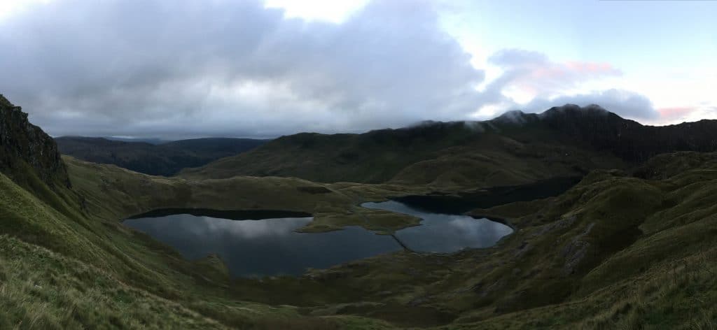
Initially the Pyg Track is tough going as you climb over big boulders and up large, man-made steps. There’s another steep push to reach a small pass called Bwlch y Moch. Here you can enjoy fabulous views of the Snowdon Horseshoe and Llyn Llydaw (llyn means lake in Welsh).
The route to Crib Goch ascends steeply to the right, but the Pig Track continues along a flatter section around the mountain. Do not turn right, but instead coontinue along the flatter path. The path continues along its’ gradual ascent until it reaches an intersection where the Miners Track joins up with the Pig Track.
From this point the trail gets much steeper and rockier until it ascends the ridge to a point called Bwlch Glas, where several other paths converge.
Once on the ridge turn left and follow the rocky path alongside the railway line to the summit.
Why is it called the Pyg Track?
There’s some dispute over where this name came from, but it’s most likely because it was the path used to carry pyg (black tar) from the Copper Works in Cwm Glaslyn.
4. The Miners Track
- Distance: 13km/8 miles
- Time: 6 – 7 hours
- Elevation gain: 723m/2372ft
- Starting Point: Pen y Pass
- Pros: This path starts off very gradually allowing plenty of time to enjoy incredible views
- Cons: A popular path. Parking at Pen y Pass is very busy, expensive and must be pre-booked in summer and weekends. Use the Sherpa Bus instead. Can be combined with the Pyg Track to make a loop.
This track starts from the south side of Pen y Pass car park and provides a gentler start than the big steps of the Pyg Track. Pass above Llyn Teryn and then over the causeway which takes you over to Llyn Llydaw.
Bearing left, the path follows the lake past some mine working ruins, before climbing steeply to Llyn Glaslyn. Walk around Glaslyn, passing some more miners ruins on your right, before climbing steeply once again.
A tall standing stone marks the point where the Miners Track joins the Pyg Track and the final steep push to the ridge. The top of the ridge marks Bwlch Glas where other paths converge. Turn left here and follow the railway line along a gradual climb to the summit.
More Hikes In Snowdonia
- Hiking Y Garn via the Devil’s Kitchen
- Pen Yr Ole Wen hiking guide
- How to hike Glyder Fawr and Glyder Fach

5. Rhyd Ddu Path
- Distance: 14km/8.5 miles
- Time: 6 – 7 hours
- Elevation gain: 895m/2936ft
- Starting Point: Rhyd Ddu car park
- Pros: Easily the quietest Snowdon route making it great for appreciating the peace and tranquility of the mountains
- Cons: Bwlch Main ridge is not suitable for very windy days
Not sure how to pronounce all of these Welsh words? Take a look at this post to learn how!
To truly escape the crowds of Snowdon head to to the village of Rhyd Ddu and take the lesser know trail to the top. Rhyd Ddu is also the starting point for a walk of Nantlle Ridge which is a fabulous ridge walk in Eryri.
From the car park in the village walk to the far end, through the large gate and over the railway. Follow the wide path keeping left at the fork and then left again at Pen ar Lon, which is marked with a stone pillar. Continue alone the trail crossing two walls and climbing more steeply until the flatter section of Llechog ridge.
Enjoy the views on this flatter section before climbing steeply again towards Bwlch Main, where the South Ridge path joins from the right.
Follow this ridge until you reach a large stone marking the point where the Watkin Path meets the ridge. Remember this point if returning the same way to make sure you stay on the correct path.
From here it’s a steep and rocky climb to the summit.


6. The Watkin Path
- Distance: 13km/8 miles
- Time: 7 – 8 hours
- Elevation gain: 1015m/3330ft
- Starting Point: Pont Bathania
- Pros: The most challenging and rewarding of the Snowdon paths
- Cons: The final ascent is a badly eroded steep scree path which isn’t much fun
With the biggest elevation gain and loose scree to contend with at the top, this is the most difficult of the these 6 Snowdon routes, but a favourite with many locals and a great UK hike.
From the car park at Pont Bethania, walk along the main road to the National Trust’s farm and campsite, Hafod y Llan. Here you will see a stone pillar marked “Watkin Path”.
Walk through the woods and around the bowl, before crossing the old tramway onto the open access land. Continue on this well made stone path, admiring waterfalls and old copper mining buildings as you ascend. A side exploration of the Watkin Path waterfalls and pools is definitely worth doing in the hot summer months, so don’t forget to pack your swimmers!
⚠️ Caution: Be careful swimming in these pools when the water is in full-flow as the waterfalls have under currents that can pull swimmers under.


After passing remains of the south Snowdon slate quarry workers’ barracks, the path ascends quite steeply to Bwlch Ciliau ridge. Turn left to continue along the Watkin path, through rocks and a grassy area until you see a Watkin Path stone pilar. Be sure to take a moment at the lookout point to admire stunning views over Llyn Llydaw.
This signifies the start of the toughest part on this trail. Weaving around rocks and boulders, the path climbs steeply and diagonally to the left. Be aware of loose stones from years of erosion.
Soon enough this path joins up to the Rhyd Ddu path, which signifies the final push to the summit.


What to pack for your Snowdon hike
- Suitable clothing: warm layers and waterproofs
- Water, food, snacks: filtering water bottles are very handy for safely refilling in streams and rivers. You can read more about filtering water bottles in this guide. Psst! I’ve secured a deal for all readers of this website. Simply use the code WWG15 at checkout to get a 15% discount off all Water-to-go bottles and filters.
- Quality hiking boots or trail shoes are a must
- The relevant map and compass, and the ability to use them!
- A first aid kit for hiking
- GPS or mapping app:A great free app option is maps.me, although the free features have now become limited. I have an annual subscription to OS which means I have access to all UK OS maps on my mobile. I can definitely recommend it if you’re a regular hiker/walker.
These are just some of the essentials, but for a complete list of things to take on a hike in Wales, take a look at this guide!
Where to stay after your Snowdon hike
Where you base yourself for your Yr Wyddfa hike very much depends on which path you decide to walk. If you want a general base for exploring Snowdonia then the best option is Betws-y-coed. Coed-y-Fron is a beautiful little B&B with views over the Conwy Valley.
For the Pyg Track, Miners Track and Llanberis Path I suggest staying in the town of Llanberis. This great little town has hiking shops for any last minute purchases, a small supermarket and lots of eateries. Try breakfast at Pete’s Eats for a great local cafe experience. Idan House is a small BnB in Llanberis which I can recommend as a base. Alternatively stay at Pen y Pass itself, at YHA Snowdon Pen y Pass Hostel.
For Rhyd Ddu, the Watkins Path or the Snowdon Ranger Path I suggest staying on the South side of the mountain. If you’re happy with a bunk house try Canolfan Awyr Agored Rhyd Ddu. For a more luxurious option, try Sygun Fawr Country House.
For a delightful hostel next to a lake and the start of the Ranger’s Path, I love the Snowdon Ranger Hostel. Finally, for the Watkins Path I suggest the very cute Bryn Dinas Camping Pods.
Walking Snowdon Paths Summary
Snowdonia National Park or Eryri is a majestic area of North Wales with many mountains to explore. The highest and most popular mountain to hike in Eryri is Mount Snowdon itself. For those unwilling or unable to hike to the top there is a steam train that provides transport to the summit. See more details about the train here.
However, for anyone wishing to hike to the top of this iconic peak there are several walking trails to explore.
For beginners there is the gradual Llanberis path and for those seeking solitude there are the Rhyd Ddu and Snowdon Ranger paths. For those wanting a big mountain challenge there is the Watkin Path and for those wanting a short, sharp ascent there are the Pyg and Miners Tracks.
Simply pick the route up Snowdon which best suits your needs and get ready for a great day in the mountains!
Did you know? Wales has 136 mountains to explore, many of which are found in the Brecon Beacons. In this guide, I discuss the best Brecon Beacons hikes to enjoy during a visit to South Wales.
Like it? Pin it for Later!
Join my Newsletter Today!
Recent Posts
11 Best Waterfalls in South Wales (With Videos & Parking Locations): 2026 Edition
South Wales is a waterfall lover’s paradise. With ancient woodland, dramatic gorges, and mountain-fed rivers, this region boasts some of the UK’s most spectacular waterfalls. Tucked away in the...
Athens' modern-day charm might captivate many tourists, but its historic side, represented by the glorious Acropolis, is unmatched. This beautiful landmark is a powerful reminder of ancient history...